






















Service Hotline
News

News

How do we know where we are without a navigation system?
2021-12-28
1134
What if you were lost somewhere on Earth? Rely on global positioning system? Okay, but what if there is no signal and no device? A map? Great idea, but what if you’re traveling on the high seas and can’t see the landmarks? Over thousands of years, many people have discovered this problem. The brave sailors then switched to using the sun and stars to navigate. For this they require a certain knowledge of geometry, especially trigonometry.
Suppose you are in the open ocean and want to calculate the latitude position. The Sun and most stars change their position in the sky over time, but some stars always seem to be in the same place. Polaris (also known as the North star), for example, always seems to be directly above the North Pole. It turns out thatYour latitude corresponds to the angle at which Polaris is above the horizon.。
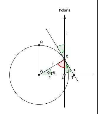
To understand why, let’s take a looktwo-dimensional image。
Consider a plane that includes the North Pole, your point X, and the center of the Earth O. Strictly speaking, Polaris is not located vertically above X, as shown in the figure, but it is so far away from the Earth that the line of sight from X to Polaris is almost vertical, so we can assume that it is.
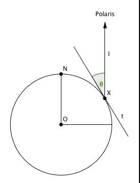
“Polaris above the horizon” The angle θ is the angle indicated in the diagram. This is the angle formed by our line of sight to Polaris (denoted l ) and the line t tangent to point X on Earth (which is our line of sight toward the horizon).
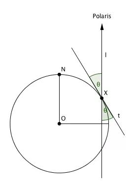
Extending t and l , we again see the angle θ on the other side of the intersection point X:
The latitude at point X is defined as the line r from O toThe angle Φ formed by the plane containing the equator.In our two-dimensional image, the equatorial plane is simply a horizontal line e passing through O.It intersects the vertical line l at point L and the tangent line t at point T.
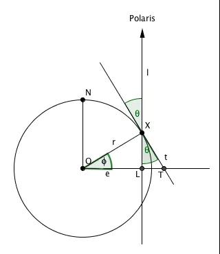
Because r is the radius of the circle and t is the tangent to the circle, we know that r and t form a right angle at point X, and since t and l form an angle θ, we know that the angle between l and r is 90°-θ.
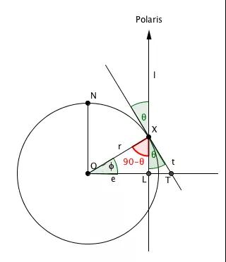
Now consider the triangle with O, X and L as vertices. As we can see, the angle at point X is 90°-θ. Since l and e are perpendicular to each other, the angle at point L is 90°. We also know that the sum of the interior angles of a triangle is 180°, so the angle Φ, which is the latitude of our location, is:

It follows that your latitude is determined by the angle θ above the horizon where Polaris lies.The Greek astronomer Hipparchus defined latitude this way 2,000 years ago. He didn't even know the earth was round at the time, but the illustrations we have here could explain why Hipparchus' definition is consistent with modern definitions.
The Southern Hemisphere does not have a North Star in the same sense, but if you are in the Southern Hemisphere, you can find your latitude using a constellation called the Southern Cross (identified on the Australian flag) and two stars called the Southern Pointer.
For thousands of years, navigators have used different devices to measure the angles at which stars appear above the horizon. These include beautiful astrolabes and sextants, which you can often see in antique shops and museums.
This solves the latitude problem, but calculating longitude is another story.
We have seen how the application of some knowledge of geometric shapes helped adventurous mariners determine latitude.People have been using the stars to do this for thousands of years. But longitude is another story.It wasn't until the 18th century that a reliable way to measure longitude was found - and before that, countless people had died at sea, and the solution to the problem was ultimately provided by clocks.
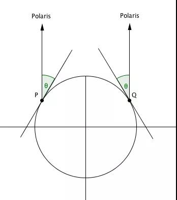
The reason we can use Polaris' position above the horizon to measure latitude is because that position changes as you move north or south (i.e., the latitude changes as well). The same cannot be said for longitude: the position of Polaris does not change longitude as you move east or west.You can see this in the 2D image below. Points P and Q lie on different meridians, but the angles caused by the position of Polaris are the same.
What changes as you move east or west is the time of day. For every 15° eastward, local time moves forward one hour, and for every 15° westward, you move back one hour. So if you know the local time and GMT you can usejet lagto calculate longitude. Even without a clock, it's easy to find the local time: you just observe the position of the sun. But the only way to know Greenwich time isCarry a (calibrated) clock with you.
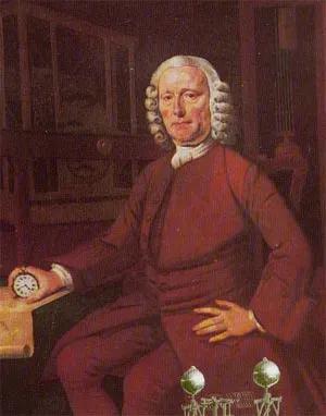
John Harrison (1693-1776)
This may seem easy today, but until recently this was a huge problem.Existing clocks were too sensitive to bring aboard: rocking and rolling would make them inaccurate.The sailors' inability to determine longitude had disastrous consequences. An example is the Shipwreck of Scilly in 1707, in which four British ships sank near the Isles of Scilly, very close to their home port of Portsmouth. As the sailors were unable to determine their exact position and in bad weather, the ships hit the rocks, killing up to 2,000 people and making it one of the worst maritime disasters in British history.
Several countries, including the Netherlands and Spain, offered huge rewards to anyone who could solve the longitude problem. Britain followed suit in 1714, offering huge rewards of up to £20,000, and various solutions were proposed. One man had an injured dog on board, which he said was barking at noon every Greenwich thanks to a mysterious alchemical cure. Others were more scientific. For example, by comparing the moon's position to that of other stars and then consulting a detailed star catalog, local time can be determined fairly accurately. However, this method is time-consuming and error-prone.
Finally it was a working class man from Lincolnshire - a joiner who won the big prize.John Harrison has been working on maritime clocks since 1730, and his latest two clocks are accurate enough to win prizes. However, since the Longitude Committee refused to pay out the full prize, denouncing the prize became a lengthy process. He appealed first to King George III and then to Parliament to rectify the matter. "By God, Harrison, I will see that you are treated right!" King George is said to have said. Harrison finally received the remaining money in 1773 along with the honors he deserved. He died three years later at the age of 83.
In addition, the story of the longitude problem is found in Dava Sobel's "longitude"The book also has a good description. If you are interested, you can read it.
This article is reprinted from "Marianne Institute of Physics, Chinese Academy of Sciences", which supports the protection of intellectual property rights. Please indicate the original source and author when reprinting. If there is any infringement, please contact us to delete it.
Related Recommendations