






















Service Hotline
News

News

Come test it out! What mobile phones support Beidou system?
2021-12-28
984
Although it is already 2018, when talking about the "Beidou System", many people's impressions may still be in 2008 - during the Wenchuan earthquake relief, it was the Beidou generation equipment that sent the first message from the earthquake area.
Generally speaking, Beidou navigation has three basic functions:Positioning, timing and unique short messages. What everyone is most concerned about may be these two questions: 1. When can Beidou be used? 2. Is Beidou easy to use? How useful is it? (Maybe the main concern is when Beidou can be used)
But actually,Your mobile phone may already be able to use Beidou navigation!
The comment under one of my most popular Weibo posts yesterday looked like this.
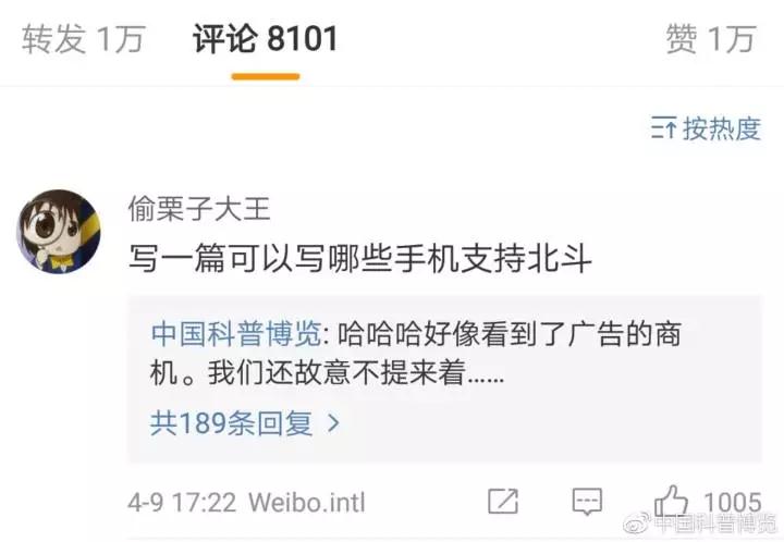
We follow the good news, and here is how to test whether your mobile phone can use Beidou navigation!
Does my mobile phone use Beidou navigation?
Do you really think that "Turn on GPS" on your phone means only using GPS?
The acquisition of Beidou signals mainly depends on the positioning chip integrated in the mobile phone processor (SOC). Currently, most SOCs can support GPS, Beidou and GlONASS at the same time: Qualcomm Snapdragon 800, 600, and 400 series. Among them, the currently common high-end models 820, 821, and 835 support Beidou, and the mid-to-low-end 652, 650, 625, 436, and even older models also support it. MediaTek is similar. The currently common P10, P15, P20, and X20, and the previous X10 all support receiving Beidou signals. Huawei HiSilicon has supported Beidou for a long time. Starting from Kirin 930, the integrated Hi1101 four-in-one chip can receive GPS, Beidou and GLonass signals at the same time. That is to say,In addition to the willful Apple, most mobile phone models from Huawei, O&V, Xiaomi, OnePlus, Meizu, HTC, Nubia and other brands that use these SOCs support Beidou positioning!
If you don’t believe it, you can try installing a test software on your phone, such as “GPS Status”, “Beidou Companion”, “AndroiTS GPS Test Pro”, etc. Take AndroiTS GPS Test Pro as an example: Find an open outdoor place and turn on the “location services” of your phone. Then run the AndroiTS GPS Test Pro software, the effect is as follows:
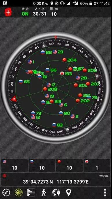
The result was that we received 10 GPS, 10 GLONASS, and 10 Beidou satellites, all of which were involved in positioning. We received one Japanese QZSS, which solved the azimuth and elevation angles, but was not used for positioning. So,Beidou is not far away from you at all. As long as you use the location service of your mobile phone, whether it is navigation or looking for nearby takeaways, Beidou is participating in it...
Surprised or not? Is it surprising? In fact, Beidou entered the mobile phone industry relatively late. Do you know that "two customers and one danger"?
"Two guests and one danger" have already used Beidou!
Two guests and one danger meansChartered buses for tourism, class III or above office buses, and special road vehicles for transporting hazardous chemicals, fireworks, and civilian explosives。
Starting from August 1, 2011, newly manufactured vehicles with "two passengers and one hazard" must be equipped with satellite positioning devices that comply with the "Technical Requirements for Vehicle-mounted Terminals of Satellite Positioning Systems for Road Transport Vehicles" before leaving the factory.
The Ministry of Transport issued a "Notice" clearly stipulating that from January 1, 2013, tourist charters, buses, and dangerous goods transport vehicles in use in various demonstration provinces that need to update their vehicle-mounted terminals should be installed with Beidou-compatible vehicle-mounted terminals; all heavy-duty trucks and semi-trailer tractors that newly enter the transportation market should be equipped with Beidou-compatible vehicles. on-board terminals and connected to the public supervision and service platform for road freight vehicles; rural passenger vehicles are encouraged to install BeiDou-compatible vehicle-mounted terminals; starting from June 1, 2013, all the above three categories of vehicles and heavy-duty trucks and semi-trailer tractors that newly enter the transportation market of demonstration provinces should be equipped with BeiDou-compatible vehicle-mounted terminals before the vehicles leave the factory. Vehicles that are not installed or retrofitted with Beidou-compatible vehicle-mounted terminals as required will not be issued or inspected for road transport certificates.
The country is so supportive, but they still say there is no Beidou around? Ran Chengqi, current director of the China Satellite Navigation System Management Office and spokesman for the Beidou System, gave a set of data: In the past five years,4.8 million operating vehicles in my country are online with "Beidou", building the world's largest Beidou Internet of Vehicles platform, and more than 40,000 fishing boats across the country are equipped with "Beidou". 他以BeijingFor example,33,500 taxis and 21,000 buses have been installed with "Beidou" to achieve full coverage of "Beidou" positioning; 1,500 logistics trucks and 19,000 delivery personnel use "Beidou" terminals and bracelets to access the logistics cloud platform to achieve real-time dispatch.
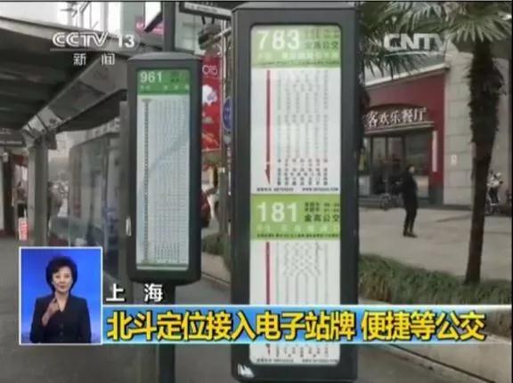
How about it? After reading the above, have you gained a new understanding of the current applications of Beidou around you and subverted the world view? To this, I want to say: Sit down, this is just a basic operation!
Beidou satellites have been running in the sky. As long as you can receive them, you can calculate the positioning results according to your own needs, reaching meter-level positioning accuracy. Apart from the money for the receiving equipment, there is no usage fee. However, do you want to get more? Do you want centimeter-level or even millimeter-level accuracy? See below.

Transportation, agriculture, surveying and mapping... Beidou is too busy!
How to improve positioning accuracy based on the 10-meter design accuracy index of the original Beidou system? This problem can be started from two parts:
One direction is from the sky, similar to the United States' DGPS (Differential GPS), Japan's Multi-Function Satellite Augmentation System (MSAS), and India's GPS-assisted Geostationary Augmentation Navigation (GAGAN). Through wide-area differential, a Satellite-Based Augmentation System (SBAS) is built. Simply put, geostationary orbit (GEO) satellites are equipped with satellite navigation signal enhancement transponders to broadcast various correction information such as ephemeris errors, satellite clock errors, and ionospheric delays to users to improve the positioning accuracy of the original satellite navigation system. At present, the third generation of Beidou has been observed by Beidou system monitoring stations and calculated differential corrections. It is broadcast through GEO satellites and can provide services for the Chinese region.Meter level or even decimeter levellocation services;
The other direction is on the ground, through the construction of the Beidou ground enhancement system to achieve positioning accuracy above centimeter level. The Beidou ground-based enhancement system consists of five parts: base station network, data processing system, operation service platform, data broadcast system and user terminal. After the base station receives the satellite navigation signal, it forms corresponding information through the data processing system, and broadcasts it to the application terminal in real time through satellite, broadcast, mobile communications and other means to achieve precise positioning services.
Have you noticed that there are a lot of these things around you recently, especially on the roofs of high-rise buildings:
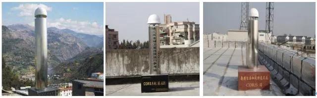
This thing is连续运行(卫星定位服务)参考站(Continuously Operating Reference Stations), abbreviated as CORS, is being built in full swing everywhere.
In the past, these CORS stations were built by local governments to receive GPS.Now with the rollout of the Beidou ground-based augmentation system, existing CORS stations in various places have been upgraded to add Beidou functions and integrated into the Beidou ground-based augmentation system to improve the functions, performance and economic benefits of the existing regional CORS station network.
byBeijingFor example, there are now CORS stations over20 seats, which can basically achieve coverageCentimeter-level positioning of the entire city. What is the concept of centimeter-level positioning?
When taking the driver's license test, you don't need to install anything on the site. You can take the test on any open space. There is no need to spend money on construction. A few white lines are drawn on the ground for you to see. The examiner only needs to set the boundaries of the moving trajectory coordinates of the Beidou positioning antenna on the test vehicle on the software. If it exceeds a few millimeters, I'm sorry for the GAME OVER...
Get your driver's license and hit the road. If you want to travel around the world, you have to use navigation software. The ordinary location service mentioned earlier can provide an accuracy of 10 meters. 10 meters can only ensure that the approximate path and direction are correct. With wide-area enhanced location services, it can provide meter-level location accuracy. Meter-level can achieve lane-level navigation. In a place like this, 10-meter accuracy is really useless...

If you spend a little more money to purchase centimeter-level high-precision positioning services, what else can you do? The answer is:Self-driving means you are not needed anymore...Why, the veteran driver is dissatisfied? Do you think you can achieve 360° centimeter-level micro-operation without any blind spots without the help of reversing radar and images...
Of course, driverless driving is still being tested and verified, but in logistics centers and docks, driverless technology has long been used. Even in farmland, driverless harvesters harvest crops, robotic arms spray water and fertilize, and drones spray pesticides. They all perform their duties in an orderly manner. This is precision agriculture.
What is precision agriculture? Do you know about flowerpot monitors? It can monitor light, temperature, water and fertilizer, which is the epitome of precision agriculture.
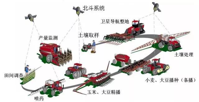
In your eyes, it is a crop. In the precision agriculture database, they are all coordinates and values. From the beginning of sowing, where the seeds are sown has been calculated. How the harvester moves and how water and fertilizer are delivered are all the results of live data calculations.Centimeter-level location services allow seemingly cumbersome machinery to accurately follow set routes without damaging crops.
With high-precision location services, agriculture has become so advanced. Of course, the main buyers of these services are enterprises or surveying and mapping users. When we talked about cooperation with surveying and mapping people in the past, they said no, your accuracy is too low and we can’t use it. Now:
"The Beidou ground-based augmentation system data center has interconnected with the Ministry of Transport, the National Bureau of Surveying, Mapping and Geoinformation, the China Earthquake Administration, the China Meteorological Administration, the Chinese Academy of Sciences, and the Ministry of Natural Resources, enabling the country's main backbone departments to begin using Beidou's enhanced data. It has begun to play a role in earthquake forecasting, national water and gas inversion, the lane-level navigation of the Ministry of Transport, and the Ya'an geological survey of the Ministry of Natural Resources."
——Cai Yi, Chief Engineer of the National Beidou Ground-Based Augmentation System
Using the foundation enhancement system, it is possible to monitor centimeter or even millimeter-level displacements. It is very convenient to monitor landslides, building deformations, and roadbed settlements. High-precision Beidou equipment for surveying and mapping can sell millions of units a year. It can be seen that the current Beidou surveying and mapping is no longer "unusable" but "unusable".Very useful"Yes.
To be continued,
This article is reproduced from "China Popular Science Expo", support the protection of intellectual property rights, please indicate the original source and author when reprinting. If there is any infringement, please contact us to delete it.
Related Recommendations