























خط تلفن خدمات
اخبار

اخبار

تحلیل مختصری از چهار سیستم ناوبری ماهوارهای اصلی جهان
2021-12-28
1151
در سرتاسر جهان4A brief analysis of large satellite navigation systems
چکیده: به منظور مطالعه بیشتر سیستمهای ناوبری ماهوارهای، تجزیه و تحلیل مقایسهای چهار سیستم ناوبری ماهوارهای جهانی موجود انجام شده است: سیستم ناوبری ماهوارهای Beidou (BDS)، سیستم موقعیتیابی جهانی (GPS)، سیستم ناوبری ماهوارهای Galileo (Galileo) و سیستم ناوبری ماهوارهای GLONASS (GLONASS) از جنبههای صورت فلکی، سیستم سیگنال، سیستم مختصات و زمان و عملکرد سرویس مقایسه شدهاند؛ به مزایای BDS اشاره شده است. نتایج نشان میدهد که BDS مزایای زیادی در صورت فلکی سیستم و رمزگذاری اطلاعات دارد و عملکرد سرویس سیستم معادل GPS و Galileo و بهتر از GLONASS است. BDS بر اساس مدار زمینایستا (GEO)، مدار زمینهمزمان شیبدار (IGSO) و زمین مزوسفری است. توزیع صورت فلکی مدارها (MEO) میتواند دقت موقعیتیابی و در دسترس بودن را در منطقه آسیا و اقیانوسیه بهبود بخشد. رمزگذاری بررسی برابری با چگالی کم 64 پایه (LDPC) که توسط BDS استفاده میشود، بهتر از روشهای رمزگذاری سایر سیستمها است. در مقایسه با کدگذاری LDPC باینری GPS، میتواند 0.6 تا 1.2 دسیبل بهره اضافی به همراه داشته باشد.
Keywords: global satellite navigation system; system constellation; signal system; coordinate system; system time; service performance
0 引言
目前有4大全球卫星导航系统(سیستم ناوبری ماهواره ای جهانی، GNSS),包括中国的北斗卫星导蟪系 ماهواره بیگ، سیستم ناوبری BeiD BDS)、美国的全球定位系统(سیستم موقعیت یاب جهانی، GPS)、欧盟的伽利略卫星导航系统(سیستم ناوبری ماهواره ای گالیله Galileo)和俄罗斯的格洛纳斯卫星导航系统(سیستم ماهواره ناوبری مداری جهانی، GLONASS)。其中,BDS和GPS已服务全球,性能相当;功能方面,BDS较GPS多了区域短报文和全球短报文功能. Although GLONASS has been in service around the world, its performance is slightly inferior to BDS and GPS, and the GLONASS orbit has a large inclination, resulting in poor performance in low latitudes. The quality of Galileo's observations is better, but the stability of the satellite clock is slightly poorer, resulting in poor system reliability.
GNSS is mainly composed of space segment, ground segment and user segment. Its working principleبه شرح زیر است:
1) The navigation satellites distributed according to the constellation in the space segment receive clock correction, ephemeris and other information injected uplink from the ground segment for signal modulation, and broadcast signals to the ground according to the prescribed signal system.
2) The ground segment tracks and maintains space satellites, monitors the health of the satellites, evaluates the integrity of the satellites and signals, determines the satellite's orbit, and injects the satellite's clock correction, ephemeris, almanac, ionospheric correction parameters and other information uplink into the satellite at specific frequencies.
۳) بخش کاربر سیگنالها را از هر ماهواره قابل مشاهده دریافت میکند و محاسبات موقعیت، سرعت و زمان (PVT) را بر اساس مشاهدات بهدستآمده از سیگنال ردیابی و اطلاعات نجومی و زمانی بهدستآمده از سیگنال دمدولهشده انجام میدهد تا اطلاعات موقعیت، سرعت و زمان کاربر را تعیین کند.The navigation system space segment mainly includes two important characteristics:
① A space constellation that represents the spatial distribution of satellites;
②Characteristics of satellite broadcast signals. As far as the entire system is concerned, what users are most concerned about is its service performance. This article mainly compares the space constellation, signal system, coordinate and time system and service performance of GNSS, and analyzes the characteristics of BDS on this basis.
۱. تحلیل مقایسهای منظومههای GNSS
The elements of a satellite navigation system space constellation mainly include constellation type, satellite type, number of satellites, orbital altitude, orbital inclination, etc. The constellation distribution of GPS, Galileo and GLONASS is roughly the same, and the satellites are all medium Earth orbit (MEO) satellites. The BDS constellation includes MEO satellites, inclined geosynchronous orbit (IGSO) satellites and geostationary orbit (GEO) satellites. BDS's three GEO satellites are located above the equator, respectively distributed at 80°E, 110.5°E and 140°E. BDS’s three IGSO satellites are distributed in three orbital planes[3]۲۴ ماهواره MEO سامانه BDS به طور مساوی در سه صفحه مداری توزیع شدهاند و مسیرهای نقطهای زیرماهوارههای آنها سراسر جهان را پوشش میدهد. سامانه BDS از طریق طرحبندی صورت فلکی MEO/IGSO/GEO میتواند دید ماهوارههای BDS را در منطقه آسیا-اقیانوسیه تا حد زیادی بهبود بخشد و در نتیجه دقت موقعیتیابی و دسترسیپذیری سامانه BDS را بهبود بخشد.
Satellite navigation system name | پارامترهای ماهواره ناوبری سیستمهای ناوبری ماهوارهای مختلف | |||||||
Constellation type | ماهواره ای | تعداد انواع مختلف ماهوارهها | انواع مختلف ارتفاع مدار ماهواره بر حسب کیلومتر | انواع مختلف ماهوارهها | انواع مختلف ماهوارهها | track surface | Constellation distribution repetition period (times/day) | |
BDS | صورت فلکی MEO از نوع Walker 24/3/1 است. | GEO آیگسو MEO | 3 3 24 | 35 786 35 786 21 528 | - 55 55 | - ۲۳ ساعت و ۵۶ دقیقه و ۴ ثانیه 12:55 p.m. | - - 3 | 13/7 (Repeat 13 times in 7 days) |
GPS | Non-Walker constellations | MEO | 24 | 20 200 | 55 | 11:58 p.m. | 6 | 2/1 (روزی ۲ بار تکرار شود) |
گالیله | Walker型星座24/3/1 | MEO | 24 | 23 222 | 56 | ۲۳ ساعت و ۵۶ دقیقه و ۴ ثانیه | 3 | 17/10 (Repeat 17 times in 10 days) |
GLONASS | Walker型星座 24/3/2 | MEO | 24 | 19 100 | 64.8 | ۲۳ ساعت و ۵۶ دقیقه و ۴ ثانیه | 3 | 17/8 (Repeat 17 times in 8 days) |
جدول1 مقایسه منظومه فضایی سیستم ناوبری ماهوارهای جهانی
2 Comparative analysis of GNSS systems
هر یک از چهار سیستم ناوبری ماهوارهای اصلی ویژگیهای خاص خود را دارند. در مورد مکانیسم دسترسی چندگانه، مکانیسم دسترسی چندگانه BDS، GPS و Galileo، دسترسی چندگانه تقسیم کد (CDMA) است. مکانیسم دسترسی چندگانه GLONASS در حال حاضر دسترسی چندگانه تقسیم فرکانس (FDMA) است. برنامه نوسازی آن توسعه به سمت CDMA است. در مورد اجزای سیگنال، علاوه بر برخی از اجزای سیگنال مجاز یا اختصاصی برای اهداف خاص، BDS، GPS و Galileo دارای ... هستند.After a period of research and coordination, a compatible and interoperable cooperation agreement was reached on civil public signals, realizing the interoperability between BDS B1C and B2a with GPS L1, L5 and Galileo E1 and E5a respectively, which can greatly improve the service performance of satellite navigation systems and reduce the development cost of multi-system user terminals.جدول ۲ عمدتاً چهار سیستم اصلی سیگنال ناوبری ماهوارهای را از جنبههای فرکانس سیگنال، شاخه سیگنال، روش مدولاسیون، روش کدگذاری اطلاعات، نرخ نماد و پهنای باند سیگنال مقایسه و تحلیل میکند تا خوانندگان بتوانند درک جامع و سیستماتیکی از سیگنالهای هر سیستم داشته باشند.
نام سیستم | سیگنال | سیگنال | Carrier frequency/MHz | روش مدولاسیون | روش کدگذاری اطلاعات | نرخ نماد (بر حسب "در ثانیه") "sampling times") | باند لوب اصلی | Broadcast satellite type |
BDS | B1I | I road | 1 561.098 | بی پی اس کی(2) | BCH(15,11,1)+ به صورت لایه لایه | 50 | 2.046 0 | موقعیت جغرافیایی/IGSO/MEO |
B1C | دادههای B1C | 1 575.420 | بی او سی (1،1) | BCH(21,6)+BCH(51,8)+64进制LDPC(200,100)+64进制LDPC(88,44)+交织 | 100 | 32.736 0 | IGSO/MEO | |
خلبان B1C | کیوامبیاوسی (۶،۱،۴/۳۳) | - | 0 | |||||
B2a | دادههای B2a | 1 176.450 | کیوپیاسکی(10) | 64 进制LDPC (96،48) | 200 | 20.460 0 | IGSO/MEO | |
خلبان B2a | - | 0 | ||||||
B2b | I road | 1 207.140 | کیوپیاسکی(10) | 64 进制LDPC (96،48) | 1000 | 20.460 0 | IGSO/MEO | |
B3I | I road | 1 268.520 | کیوپیاسکی(10) | BCH(15,11,1)+ به صورت لایه لایه | 50 | 20.460 0 | موقعیت جغرافیایی/IGSO/MEO | |
GPS | L1 | C/A | 1 575.420 | بی پی اس کی(1) | Hamming code (32,26) | 50 | 2.046 0 | MEO |
پ(ی) | بی پی اس کی(10) | رمزگذاری | 50 | 20.460 0 | ||||
M | بی او سی (1،1) | رمزگذاری | - | 30.690 0 | ||||
L1C | L1C-D | 1 575.420 | بی او سی (1،1) | CRC-24Q+BCH(51,8)+binary LDPC(1200,600)+block interleaving | 100 | 4.092 0 | MEO | |
L1C-P | TMBOC (6،1،4/33) | - | - | 14.332 0 | ||||
L2 | پ(ی) | 1 227.600 | بی پی اس کی(10) | رمزگذاری | 50 | 20.460 0 | MEO | |
C | بی پی اس کی(1) | CRC-24Q+ convolutional encoding (600,300) | 50 | 2.046 0 | ||||
M | بی او سی (1،1) | رمزگذاری | - | 30.690 0 | ||||
L5 | L5C | 1 176.450 | کیوپیاسکی(10) | CRC-24Q+ convolutional encoding (600,300) | 100 | 20.460 0 | MEO | |
L5Q | رمزگذاری | - | ||||||
گالیله | E1 | E1-A | 1 575.420 | BOCCOS(15,2.5) | رمزگذاری | 100 | 35.805 0 | MEO |
E1-B | CBOC(6،1،1/11، '+') | CRC-24Q + convolutional encoding (240,120) + interleaving | 4.092 0 | |||||
E1-C | CBOC(6،1،1/11، '+') | - | 4.092 0 | |||||
E5a | E5a-I | 1 176.450 | AltBOC(15,10) | CRC-24Q + convolutional encoding (488,244) + interleaving | 50 | 51.150 0 | MEO | |
E5b | E5b-I | 1 207.140 | CRC-24Q + convolutional encoding (240,120) + interleaving | 250 | ||||
E6 | E6-A | 1 278.750 | BOCCOS(10,5) | رمزگذاری | 100 | 30.690 0 | MEO | |
E6-B | بی پی اس کی(5) | رمزگذاری | 1000 | 10.230 0 | ||||
E6-C | بی پی اس کی(5) | - | - | 10.230 0 | ||||
GLONASS | G1 | ۱ ۵۹۸.۰ ۶۲۵~۱ ۶۰۵.۳۷۵ | BPSK | کد چکش | 100 | 8.334 5 | MEO | |
G2 | ۱ ۵۹۸.۰ ۶۲۵~۱ ۶۰۵.۳۷۵ | BPSK | کد چکش | 100 | 6.709 5 | |||
جدول2 GNSSComparison of signaling systems[4-9]
表 2: BPSK (کلیدینگ تغییر فاز باینری) اپراتور) حامل افست باینری)表示复合二进制偏移载波;BCH(Bose Chaudhuri Hocquenghem)表示Bose、Chaudhuri及Hocquendhem各自独立发现的二元线性循环码;CRC (بررسی افزونگی چرخهای)表示循立As can be seen from Table 2, the B1C signal of BDS, the L1C signal of GPS and the E1 signal of Galileo work at 1 575.42 MHz, and the debugging method is binary offset carrier (BOC) type modulation; the B2a signal of BDS, the L5 signal of GPS and the E5a signal of Galileo work at 1 176.45 MHz, where B2a and L5 are quadrature phase shift keying (QPSK) modulation methods, and E5a is alternating binary offset carrier (AltBOC) modulation method. The consistency of frequencies and the similarity of modulation methods create prerequisites for GNSS compatibility and interoperability. Currently, compatibility and interoperability can be achieved very well at 1 575.42 MHz.از نظر طراحی پیام ناوبری، BDS کدگذاری 64 پایهای بررسی برابری با چگالی پایین (LDPC) را به عنوان یک ویژگی مهم در کدگذاری پیام ناوبری معرفی کرد. طرحهای کدگذاری و رمزگشایی آن به طور مستقل توسط چین توسعه داده شد و عملکرد آن در مقایسه با کدگذاری LDPC باینری GPS بسیار بهبود یافته است. پیچیدگی کدگذاری 64 پایهای LDPC و کدگذاری LDPC باینری اساساً یکسان است. از نظر رمزگشایی، پیچیدگی رمزگشایی 64 پایهای حدود 6 برابر رمزگشایی باینری است. نرخ خطای بیت 1×10 است.-5تحت این شرایط، بهره کدگذاری LDPC 64-آرایه 0.6 تا 1.2 دسیبل بیشتر از بهره کدگذاری LDPC باینری است که مزایای قابل توجهی را برای بهبود شاخصهای مربوط به شروع سرد ترمینال کاربر به همراه دارد..
۳ تحلیل تطبیقی مختصات GNSS و سیستمهای زمانی
3.1 Comparative analysis of coordinate systems
The coordinate system of the satellite navigation system is particularly important. The satellite position and satellite speed calculated from the satellite ephemeris parameters and almanac parameters are directly represented in the system coordinate system. The system coordinate system defines the datum ellipsoid required to establish the corresponding geodetic coordinate system, describes the Earth's gravity field model corresponding to the geoid, and provides corrected basic geodetic parameters. The corrected basic geodetic parameters of each system are shown in Table 3.
نام سیستم | نام سیستم مختصات | Coordinate system parameters | |||
طول بیضوی/متر | oblateness | ثابت گرانشی/ | سرعت زاویهای چرخش زمین/ | ||
BDS | بی دی سی اس | 6 378 137.00 | 1 / 298.257 222 101 | 3.986 004 418 | 7.292 115 |
GPS | WGS84 | 6 378 137.00 | 1 / 298.257 223 563 | 3.986 004 418 | 7.292 115 |
گالیله | جیتیآراف | 6 378 136.55 | 1 / 298.257 690 000 | 3.986 004 418 | 7.292 115 146 7 |
GLONASS | PZ90 | 6 378 136.00 | 1 / 298.257 839 303 | 3.986 004 418 | 7.292 115 |
جدول3 پارامترهای ژئودزیکی پایه هر سیستم مختصات[4-9]
سیستم مختصات BeiDou (BDCS) یک سیستم مرجع زمین ژئوسنتریک است. تعریف BDCS با مشخصات سرویس بینالمللی چرخش زمین (IERS) مطابقت دارد و از پارامترهای بیضوی مرجع سیستم مختصات ژئودزی چین 2000 (CGCS2000) استفاده میکند. تفاوت اصلی آن با CGCS2000 فرکانس بهروزرسانی است. BDCS یک سیستم مختصات ویژه برای BDS است و میتواند سالی یک بار یا شش ماه یک بار بهروزرسانی شود. CGCS2000 یک سیستم مختصات ملی با طیف گستردهای از همبستگیها و یک بازه بهروزرسانی طولانی است. پیادهسازی BDCS با جدیدترین چارچوب مرجع زمینی بینالمللی (ITRF) همسو خواهد بود. WGS84 (سیستم ژئودزی جهانی 84) سیستم مختصات ژئودزی مورد استفاده GPS ایالات متحده است. GTRF (چارچوب مرجع زمینی گالیله) سیستم مختصات ژئودزی مورد استفاده گالیله اتحادیه اروپا است. PZ-90 (سیستم ژئودزی PZ-90) سیستم مختصات ژئودزی است که توسط روسیه تأسیس شده است.
3.2 Comparative analysis of time systems
The time system is the core of the satellite navigation system and the cornerstone of the normal operation of the satellite navigation system. BDS, GPS and Galileo have all established dedicated time systems based on atomic time (AT). Their second lengths are synthesized based on the observations of atomic clocks and satellite atomic clocks installed on their ground monitoring stations. They are still essentially atomic time and therefore continuous, without the need for leap seconds like coordinated universal time. GLONASS system time (GLONASST) is different from the other three system times. It is an atomic time system similar to coordinated universal time (UTC). It introduces leap seconds during operation, uses Moscow time as the benchmark, and traces its origin to the coordinated universal time UTC (SU) maintained by the Russian Institute of Time Metrology.زمان BeiDou (BDT) توسط ایستگاه کنترل اصلی BDS تولید و نگهداری میشود و قابل ردیابی به زمان هماهنگ جهانی (NTSC) است که توسط مرکز خدمات ملی زمان نگهداری میشود. زمان GPS (زمان GPS، GPST) توسط ایستگاه کنترل اصلی GPS تولید و نگهداری میشود و قابل ردیابی به زمان هماهنگ جهانی UTC (USNO) است که توسط رصدخانه نیروی دریایی ایالات متحده نگهداری میشود.[12]。Galileo时(Galileo time, GST)直接溯源到国际计量局(دفتر بینالمللی وزنها و اندازهها، BIPM)保持的协调زمان اتمی بینالمللی (TAI) بر حسب ثانیه اتمی اندازهگیری میشود و از زمان جهانی (UT) ساعت 0:00 در اول ژانویه 1958 شروع میشود. در این زمان، اختلاف بین زمان جهانی و زمان اتمی بینالمللی صفر است و سپس سال به سال افزایش مییابد. در سال 1972، به منظور هماهنگ کردن اختلافات بین زمان اتمی بینالمللی و زمان جهانی، یک طرح سازش با نام زمان هماهنگ جهانی پیشنهاد شد. زمان هماهنگ جهانی بر اساس طول ثانیه دقیق TAI است. هنگامی که اختلاف بین آن و زمان جهانی از 0.9 ثانیه بیشتر شود، یک ثانیه کبیسه به صورت مصنوعی 1 ثانیه اضافه میشود، به طوری که اختلاف بین زمان جهانی و زمان هماهنگ جهانی همیشه در محدوده 0.9 ثانیه باشد.[13]. The system time comparison of the four major satellite navigation systems is shown in Table 4.
ناوبری ماهواره ای | پارامترهای سیستم زمانی سیستمهای ناوبری ماهوارهای مختلف | |||
نام سیستم زمانی | دوره شروع | Is it continuous? | Lag TAI time/s | |
BDS | BDT | 2006-01-01 00:00:00(UTC) | بله | 33 |
GPS | جیپیاستی | 1980-01-06 00:00:00(UTC) | بله | 19 |
گالیله | GST | 1999-08-22 00:00:00(UTC)前13 s | بله | 19 |
GLONASS | گلوناس | 滞后UTC(SU) 3 ساعت | نه | Changes with leap seconds |
جدول4 GNSSمقایسه سیستم زمانی
According to comparative analysis, the starting epoch of GST is set to 13 seconds before 1999-08-22T 00:00:00 (UTC) in order to be consistent with GPST. Both GST and GPST lag TAI by 19 seconds.
The conversion relationship between each system time is shown in Figure 1.
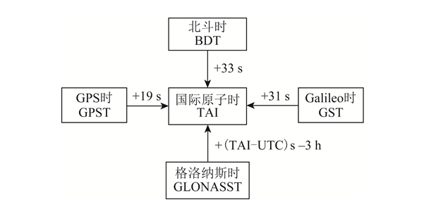
تصویر1 رابطه تبدیل زمان سیستم
۴ تحلیل مقایسهای عملکرد سرویس GNSS
The service performance of satellite navigation systems includes accuracy, integrity, continuity and availability, of which users are most concerned about accuracy and availability.دقت سرویس شامل دقت موقعیتیابی، دقت اندازهگیری سرعت و دقت اندازهگیری زمان است. دقت موقعیتیابی، مقدار آماری تفاوت بین موقعیت تعیینشده توسط کاربر با استفاده از سیگنالهای ماهوارهای و موقعیت واقعی آن، شامل دقت موقعیتیابی افقی و دقت موقعیتیابی عمودی است. دقت اندازهگیری سرعت، مقدار آماری تفاوت بین سرعت تعیینشده توسط کاربر با استفاده از سیگنالهای ماهوارهای و سرعت واقعی آن است که عموماً خطای سرعت فضای سهبعدی است. دقت اندازهگیری زمان، مقدار آماری تفاوت بین زمان تعیینشده با استفاده از سیگنالهای ماهوارهای و زمان سیستم ناوبری ماهوارهای است.Service availability is the ratio of system service time to expected service time. The serviceable time is the time when the position dilution of precision (PDOP) availability and positioning availability within the specified area meet the requirements. PDOP availability is the percentage of time that the PDOP value meets the threshold requirements within a specified geographical or spatial area and time period. Positioning availability is the percentage of time that the positioning accuracy meets the threshold requirements within the specified service area and time period.The positioning accuracy of the navigation system is mainly determined by two factors: ① PDOP value; ② user equivalent range error (UERE). UERE consists of user range error (URE) and user equipment error (UEE). Among them: URE is the sum of errors in the distance observation from the satellite to the user terminal caused by errors in the navigation satellite orbit and satellite clock error, which is mainly determined by the satellite navigation system; UEE is the error caused by ground multipath effects and user receiver loop noise, etc., which is mainly determined by the use environment and the design of the local receiver.بر اساس مشخصات عملکرد سرویس و آخرین مطالب رسمی کنفرانس از BDS، GPS، Galileo و GLONASS[3,14-17], the public service performance parameters of each global satellite navigation system were sorted out, and the results are shown in Table 5. In Table 5, RMS (root mean square) represents the root mean square.
نام سیستم | اوره/متر | اورره/(میلی ثانیه)-1) | دقت موقعیتیابی بر متر با قابلیت اطمینان ۹۵٪ | Speed measurement accuracy/ | قابلیت اطمینان 95٪ | |
جهت افقی | جهت ارتفاع | |||||
BDS | B1C/B2a:0.6(RMS) | 0.006 (RMS) | 10 | 10 | ۰.۲ (۹۵٪) | 20 |
B1I/B3I:1(RMS) | ||||||
GPS | نتیجه با ضریب اطمینان ۹۵٪، ۷.۸ است. | نتیجه با ضریب اطمینان ۹۵٪، ۷.۸ است. | 9 | 15 | 0.1 | 40 |
گالیله | نتیجه با ضریب اطمینان ۹۵٪، ۷.۸ است. | - | 4 | 8 | - | 30 |
GLONASS | نتیجه با ضریب اطمینان ۹۵٪، ۷.۸ است. | نتیجه با ضریب اطمینان ۹۵٪، ۷.۸ است. | 5 | 9 | - | 700 |
جدول5 GMSSپارامترهای عملکرد سرویس را افشا کنید
در واقع، عملکرد اندازهگیری شده هر سیستم ناوبری ماهوارهای بهتر از عملکرد وعده داده شده برای خدمات عمومی است. طبق گزارش دفتر مدیریت ماهواره چین در چهاردهمین نشست کمیته بینالمللی سیستم ماهوارهای ناوبری جهانی (ICG) در سال ۲۰۱۹[18], the measured horizontal positioning accuracy of BDS B1I/B3I is 3.6 m (result under 95% reliability), the altitude positioning accuracy is 6.6 m (result under 95% reliability), the speed measurement accuracy is 0.05 m/s (result under 95% reliability), and the timing accuracy is 9.8 ns (result under 95% reliability). The measured horizontal positioning accuracy of B1C/B2a is 2.4 m (95 The result under 95% reliability), the altitude positioning accuracy is 4.3 m (the result under 95% reliability), the speed measurement accuracy is 0.06 m/s (the result under 95% reliability), and the timing accuracy is 19.1 ns (the result under 95% reliability).According to the National Coordination Office of the 14th ICG Conference in 2019室(دفتر هماهنگی ملی، NCO)的报告[19], the statistical results from 2018-11-14 to 2019-11-13 show that the average URE of GPS is 0.514 m, the best day URE is 0.362 m, and the worst day URE is 0.666 m. According to the report of the European Space Agency at the 14th ICG Conference in 2019[20-21]، خطای URE ماهواره گالیله که در سپتامبر ۲۰۱۹ محاسبه شد، ۰.۲۷ متر بود (نتیجه زیر ۹۵٪ قابلیت اطمینان) و بدترین دقت موقعیتیابی مشاهده شده در منطقه استوایی ۲.۷۹ متر بود (نتیجه زیر ۹۵٪ قابلیت اطمینان).
نتیجه گیری 5
این مقاله مقایسه دقیقی از چهار سامانه GNSS موجود انجام میدهد، ویژگیهای منظومههای سیستم را تجزیه و تحلیل میکند و مزایای منظومه ترکیبی BOS MEO/IGSO/GEO را برجسته میکند؛ سیستم سیگنال هر سیستم ناوبری را خلاصه میکند و مزایای سازگاری و قابلیت همکاری چند سیستمی و رمزگذاری اطلاعات BDS را برجسته میکند؛ تجزیه و تحلیل مقایسهای از سیستم مختصات و سیستم زمان هر سیستم انجام میدهد؛ عملکرد سرویس سیستم ناوبری ماهوارهای را تجزیه و تحلیل میکند،پارامترهای عملکرد سرویس هر سیستم ناوبری خلاصه شدهاند.از طریق تجزیه و تحلیل مقایسهای، میتوان مشاهده کرد که پس از جهانی شدن BDS، این سامانه دارای فناوری پیشرفته، عملکردهای کامل، عملکرد عالی، سازگاری و قابلیت همکاری عالی با GPS و Galileo است و از حقوق مالکیت معنوی کاملاً مستقلی برخوردار است. این سامانه در مرحله اجرا در کنار GPS است که تضمین مهمی برای جهانی شدن BDS و تبدیل شدن به جریان اصلی بینالمللی فراهم میکند. با توجه به اینکه این کشور همچنان به سرمایهگذاری سنگین در منابع و نیروی انسانی ادامه میدهد، انتظار میرود BDS در آینده نزدیک پیشرو GNSS خارجی باشد.
This article is reprinted from "Surveying and Mapping Academic Information" to support the protection of intellectual property rights. Please indicate the original source and author when reprinting. If there is any infringement, please contact us to delete it.
توصیههای مرتبط
Kinghelm پنگ هوییشنگ، معاون مدیر فروش: یک هاکا در شنژن، که با سختکوشی به آرمان اولیهاش وفادار مانده است
2026-08-03
2243
اشتیاق دانشگاه Tsinghua: غلبه بر چالش ها در علم مواد - مصاحبه با Cen Jianjun از CEN Ningbo Jinshan New Materials Company
2026-07-14
2624