























Service Hotline
Nieuws

Nieuws

Een korte analyse van de vier belangrijkste satellietnavigatiesystemen ter wereld.
2021-12-28
1151
wereldwijd4Een korte analyse van grote satellietnavigatiesystemen
Abstract: In order to further study satellite navigation systems, a comparative analysis of the four existing global satellite navigation systems is conducted: Beidou Satellite Navigation System (BDS), Global Positioning System (GPS), Galileo Satellite Navigation System (Galileo) and GLONASS Satellite Navigation System (GLONASS) are compared from the aspects of constellation, signal system, coordinate and time system and service performance; the advantages of BDS are pointed out. The results show that BDS has great advantages in system constellation and information encoding, and the system service performance is equivalent to GPS and Galileo, and better than GLONASS; BDS is based on geostationary orbit (GEO), inclined geosynchronous orbit (IGSO) and mesospheric earth The constellation distribution of orbits (MEO) can improve positioning accuracy and availability in the Asia-Pacific region; the 64-base low-density parity check (LDPC) encoding used by BDS is better than the encoding methods of other systems. Compared with the binary LDPC encoding of GPS, it can bring 0.6~1.2 dB of additional gain.
Trefwoorden: wereldwijd satellietnavigatiesysteem; systeemconstellatie; signaalsysteem; coördinatensysteem; systeemtijd; serviceprestaties
0 reacties
目前有4大全球卫星导航系统(wereldwijd satellietnavigatiesysteem, GNSS),包括中国的北斗卫星导航系统(BeiDou navigatiesatellietsysteem, BDS)、美国的全球定位系统(global positioning system, GPS)、欧盟的伽利略卫星导航系统(Galileo navigatiesatellietsysteem, Galileo)和俄罗斯的格洛纳斯卫星导航系统(mondiaal in een baan om de aarde draaiende navigatiesatellietsysteem, GLONASS)。其中,BDS和GPS已服务全球,性能相当;功能方面,BDS较GPS多了区域短报文和全球短报文功能Hoewel GLONASS wereldwijd in gebruik is, zijn de prestaties ervan iets minder dan die van BDS en GPS. Bovendien heeft de GLONASS-baan een grote hellingshoek, wat resulteert in slechte prestaties op lage breedtegraden. De kwaliteit van de waarnemingen van Galileo is beter, maar de stabiliteit van de satellietklok is iets minder, wat leidt tot een lagere systeembetrouwbaarheid.
GNSS bestaat hoofdzakelijk uit een ruimtesegment, een grondsegment en een gebruikerssegment. Het werkingsprincipe ervanals volgt:
1) The navigation satellites distributed according to the constellation in the space segment receive clock correction, ephemeris and other information injected uplink from the ground segment for signal modulation, and broadcast signals to the ground according to the prescribed signal system.
2) Het grondsegment volgt en onderhoudt ruimtesatellieten, bewaakt de conditie van de satellieten, evalueert de integriteit van de satellieten en signalen, bepaalt de baan van de satelliet en stuurt de klokcorrectie, efemeriden, almanak, ionosferische correctieparameters en andere informatie via een uplink naar de satelliet op specifieke frequenties.
3) The user segment receives signals from each visible satellite, and performs position, velocity, and time (PVT) calculations based on the observations obtained from the tracking signal and the ephemeris and time information obtained from the demodulated signal to determine the user's position, velocity, and time information.Het ruimtesegment van het navigatiesysteem omvat hoofdzakelijk twee belangrijke kenmerken:
① Een ruimteconstellatie die de ruimtelijke verdeling van satellieten weergeeft;
②Characteristics of satellite broadcast signals. As far as the entire system is concerned, what users are most concerned about is its service performance. This article mainly compares the space constellation, signal system, coordinate and time system and service performance of GNSS, and analyzes the characteristics of BDS on this basis.
1. Vergelijkende analyse van GNSS-constellaties
De elementen van een satellietnavigatiesysteem (SDS) omvatten hoofdzakelijk het type constellatie, het type satelliet, het aantal satellieten, de baanhoogte, de baanhelling, enzovoort. De constellatieverdeling van GPS, Galileo en GLONASS is ongeveer gelijk en de satellieten bevinden zich allemaal in een middelhoge aardbaan (MEO). De BDS-constellatie omvat MEO-satellieten, satellieten in een hellende geosynchrone baan (IGSO) en satellieten in een geostationaire baan (GEO). De drie GEO-satellieten van BDS bevinden zich boven de evenaar, respectievelijk op 80°O, 110.5°O en 140°O. De drie IGSO-satellieten van BDS zijn verdeeld over drie verschillende baanvlakken.[3]. BDS's 24 MEO satellites are evenly distributed in three orbital planes, and their subsatellite point trajectories cover the world. Through the MEO/IGSO/GEO constellation layout, BDS can greatly improve the visibility of BDS satellites in the Asia-Pacific region, thereby improving the positioning accuracy and availability of BDS.
Naam satellietnavigatiesysteem | Navigatiesatellietparameters van verschillende satellietnavigatiesystemen | |||||||
Soort sterrenbeeld | satelliet | Aantal verschillende soorten satellieten | Different types of satellite orbit heights/km | different types of satellites | different types of satellites | baanoppervlak | Herhalingsperiode voor constellatiedistributie (times/day) | |
BDS | MEO's constellation is Walker type 24/3/1 | GEO IGSO MEO | 3 3 24 | 35 786 35 786 21 528 | - 55 55 | - 23 uur 56 min 4 s 12 55 h min | - - 3 | 13/7 (Repeat 13 times in 7 days) |
GPS | Niet-Walker-sterrenbeelden | MEO | 24 | 20 200 | 55 | 11 58 h min | 6 | 2/1 (Herhaal dit 2 keer per dag) |
Galileo | Walker is actief op 24/3/1 | MEO | 24 | 23 222 | 56 | 14 uur 4 min 45 s | 3 | 17/10 (Repeat 17 times in 10 days) |
GLONASS | Walker is 24/3/2 beschikbaar | MEO | 24 | 19 100 | 64.8 | 11 uur 15 min 44 s | 3 | 17/8 (Repeat 17 times in 8 days) |
表1 Global satellite navigation system space constellation comparison
2. Vergelijkende analyse van GNSS-systemen
Each of the four major satellite navigation systems has its own characteristics. As for the multi-access mechanism, the multi-access mechanism of BDS, GPS and Galileo is code division multiple access (CDMA). The multi-access mechanism of GLONASS is currently frequency division multiple access (FDMA). Its modernization plan is to develop towards CDMA. As far as signal components are concerned, in addition to some authorized or proprietary signal components for special purposes, BDS, GPS and Galileo haveAfter a period of research and coordination, a compatible and interoperable cooperation agreement was reached on civil public signals, realizing the interoperability between BDS B1C and B2a with GPS L1, L5 and Galileo E1 and E5a respectively, which can greatly improve the service performance of satellite navigation systems and reduce the development cost of multi-system user terminals.Tabel 2 vergelijkt en analyseert hoofdzakelijk de vier belangrijkste satellietnavigatiesignaalsystemen vanuit de aspecten signaalfrequentie, signaaltak, modulatiemethode, informatiecoderingsmethode, symboolsnelheid en signaalbandbreedte, zodat lezers een uitgebreid en systematisch inzicht krijgen in de signalen van elk systeem.
Systeemnaam | Signaal | Signaal | Draagfrequentie/MHz | modulatie methode | Informatiecoderingmethode | Symboolsnelheid (in "per seconde") "sampling times") | hoofdlobband | Type satellietuitzending |
BDS | B1I | Ik rijd | 1 561.098 | BPSK(2) | BCH(15,11,1)+interleaved | 50 | 2.046 0 | GEO/IGSO/MEO |
B1C | B1C_gegevens | 1 575.420 | BOC(1,1) | BCH(21,6)+BCH(51,8)+64进制LDPC(200,100)+64进制LDPC(88,44)+交织 | 100 | 32.736 0 | IGSO/MEO | |
B1C_piloot | QMBOC(6,1,4/33) | - | 0 | |||||
B2a | B2a_gegevens | 1 176.450 | QPSK(10) | 64 dagen geledenLDPC(96,48) | 200 | 20.460 0 | IGSO/MEO | |
B2a_piloot | - | 0 | ||||||
B2b | Ik rijd | 1 207.140 | QPSK(10) | 64 dagen geledenLDPC(162,81) | 1000 | 20.460 0 | IGSO/MEO | |
B3I | Ik rijd | 1 268.520 | QPSK(10) | BCH(15,11,1)+interleaved | 50 | 20.460 0 | GEO/IGSO/MEO | |
GPS | L1 | C/A | 1 575.420 | BPSK(1) | Hamming-code (32,26) | 50 | 2.046 0 | MEO |
P(Y) | BPSK(10) | encryptie | 50 | 20.460 0 | ||||
M | BOC(10,5) | encryptie | - | 30.690 0 | ||||
L1C | L1C-D | 1 575.420 | BOC(1,1) | CRC-24Q+BCH(51,8)+binaire LDPC(1200,600)+blokinterleaving | 100 | 4.092 0 | MEO | |
L1C-P | TMBOC(6,1,4/33) | - | - | 14.332 0 | ||||
L2 | P(Y) | 1 227.600 | BPSK(10) | encryptie | 50 | 20.460 0 | MEO | |
C | BPSK(1) | CRC-24Q+ convolutional encoding (600,300) | 50 | 2.046 0 | ||||
M | BOC(10,5) | encryptie | - | 30.690 0 | ||||
L5 | L5C | 1 176.450 | QPSK(10) | CRC-24Q+ convolutional encoding (600,300) | 100 | 20.460 0 | MEO | |
L5Q | encryptie | - | ||||||
Galileo | E1 | E1-A | 1 575.420 | BOCCOS(15,2.5) | encryptie | 100 | 35.805 0 | MEO |
E1-B | CBOC(6,1,1/11,'+') | CRC-24Q + convolutional encoding (240,120) + interleaving | 4.092 0 | |||||
E1-C | CBOC(6,1,1/11,'+') | - | 4.092 0 | |||||
E5a | E5a-I | 1 176.450 | AltBOC(15,10) | CRC-24Q + convolutional encoding (488,244) + interleaving | 50 | 51.150 0 | MEO | |
E5b | E5b-I | 1 207.140 | CRC-24Q + convolutional encoding (240,120) + interleaving | 250 | ||||
E6 | E6-A | 1 278.750 | BOCCOS(10,5) | encryptie | 100 | 30.690 0 | MEO | |
E6-B | BPSK(5) | encryptie | 1000 | 10.230 0 | ||||
E6-C | BPSK(5) | - | - | 10.230 0 | ||||
GLONASS | G1 | 1 598.0 625~1 605.375 | BPSK | Hamming-code: | 100 | 8.334 5 | MEO | |
G2 | 1 242.9 375~1 248.625 | BPSK | Hamming-code: | 100 | 6.709 5 | |||
表2 GNSSComparison of signaling systems[4-9]
表2中:BPSK(binary phase shift keying)表示二相移相键控;QMBOC(kwadratuur multiplexed binary offset carrier)表示正交复用二进制偏移载波调制;TMBOC(tijd multiplexed binary offset carrier)表示时分复用二进制偏移载波;CBOC (samengestelde binaire offset carrier)表示复合二进制偏移载波;BCH (Bose Chaudhuri Hocquenghem)表示Bose、Chaudhuri及Hocquendhem各自独立发现的二元线性循环码;CRC (cyclische redundantiecontrole)表示循环冗余校验。Zoals blijkt uit tabel 2, werken het B1C-signaal van BDS, het L1C-signaal van GPS en het E1-signaal van Galileo op 1575,42 MHz, en de debugmethode is binaire offset-carrier (BOC)-modulatie; het B2a-signaal van BDS, het L5-signaal van GPS en het E5a-signaal van Galileo werken op 1176,45 MHz, waarbij B2a en L5 gebruikmaken van kwadratuurfaseverschuivingsmodulatie (QPSK) en E5a van alternerende binaire offset-carrier (AltBOC)-modulatie. De consistentie van de frequenties en de gelijkenis van de modulatiemethoden creëren de voorwaarden voor GNSS-compatibiliteit en -interoperabiliteit. Momenteel kunnen compatibiliteit en interoperabiliteit zeer goed worden bereikt op 1575,42 MHz.In terms of navigation message design, BDS introduced 64-base low density parity check (LDPC) encoding as an important feature into navigation message encoding. Its encoding and decoding schemes were independently developed by China, and its performance is greatly improved compared to the binary LDPC encoding of GPS. The complexity of 64-base LDPC encoding and binary LDPC encoding are basically the same; in terms of decoding, the complexity of 64-base decoding is about 6 times that of binary decoding. Bit error rate is 1×10⁻⁵Onder deze omstandigheden is de coderingswinst van 64-ary LDPC 0.6 tot 1.2 dB hoger dan die van binaire LDPC, wat aanzienlijke voordelen oplevert voor de verbetering van de opstartprestaties van de gebruikersterminal..
3. Vergelijkende analyse van GNSS-coördinaten en tijdsystemen
3.1 Vergelijkende analyse van coördinatensystemen
Het coördinatensysteem van het satellietnavigatiesysteem is van bijzonder belang. De positie en snelheid van de satelliet, berekend op basis van de efemeriden en almanakparameters, worden direct weergegeven in het coördinatensysteem. Dit coördinatensysteem definieert de referentie-ellipsoïde die nodig is om het corresponderende geodetische coördinatensysteem vast te stellen, beschrijft het zwaartekrachtveldmodel van de aarde dat overeenkomt met de geoïde en levert gecorrigeerde basisgeodetische parameters. De gecorrigeerde basisgeodetische parameters van elk systeem worden weergegeven in tabel 3.
Systeemnaam | Naam van coördinatensysteem | Coördineer systeemparameters | |||
Ellipsoïde lengte/m | oblateness | zwaartekrachtconstante/ | hoeksnelheid van de rotatie van de aarde/ | ||
BDS | BDCS | 6 378 137.00 | 1 / 298.257 222 101 | 3.986 004 418 | 7.292 115 |
GPS | WGS84 | 6 378 137.00 | 1 / 298.257 223 563 | 3.986 004 418 | 7.292 115 |
Galileo | GTRF | 6 378 136.55 | 1 / 298.257 690 000 | 3.986 004 418 | 7.292 115 146 7 |
GLONASS | PZ90 | 6 378 136.00 | 1 / 298.257 839 303 | 3.986 004 418 | 7.292 115 |
表3 Fundamentele geodetische parameters van elk coördinatensysteem[4-9]
The BeiDou coordinate system (BDCS) is a geocentric earth reference system. The definition of BDCS complies with the International Earth Rotation Service (IERS) specification and uses the reference ellipsoid parameters of China geodetic coordinate system 2000 (CGCS2000). The main difference from CGCS2000 is the update frequency. BDCS is a special coordinate system for BDS and can be updated once a year or half a year; CGCS2000 is a national coordinate system with a wide range of correlations and a long update interval. The implementation of BDCS will be aligned with the latest international terrestrial reference frame (ITRF). WGS84 (world geodetic system 84) is the geodetic coordinate system used by the US GPS; GTRF (Galileo terrestrial reference frame) is the geodetic coordinate system used by the EU Galileo; PZ-90 (PZ-90 geodetic system) is the geodetic coordinate system established by Russia.
3.2 Vergelijkende analyse van tijdsystemen
Het tijdsysteem vormt de kern van het satellietnavigatiesysteem en is de hoeksteen van de normale werking ervan. BDS, GPS en Galileo hebben alle drie eigen tijdsystemen gebaseerd op atoomtijd (AT). De lengte van hun seconden wordt berekend op basis van waarnemingen van atoomklokken en satellietatoomklokken die op hun grondstations zijn geïnstalleerd. Het is in essentie nog steeds atoomtijd en daarom continu, zonder de noodzaak van schrikseconden zoals bij de gecoördineerde universele tijd. De tijd van het GLONASS-systeem (GLONASST) verschilt van de andere drie systemen. Het is een atoomtijdsysteem vergelijkbaar met de gecoördineerde universele tijd (UTC). Het introduceert schrikseconden tijdens de werking, gebruikt Moskoutijd als referentiepunt en vindt zijn oorsprong in de gecoördineerde universele tijd UTC (SU) die wordt beheerd door het Russische Instituut voor Tijdmetrologie.BeiDou-tijd (BDT) wordt gegenereerd en beheerd door het BDS-hoofdcontrolecentrum en is herleidbaar tot de Coordinated Universal Time (NTSC), beheerd door het National Time Service Center. GPS-tijd (GPS-tijd, GPST) wordt gegenereerd en beheerd door het GPS-hoofdcontrolecentrum en is herleidbaar tot de Coordinated Universal Time (UTC, USNO), beheerd door het US Naval Observatory.[12]。Galileo时(Galileo time, GST)直接溯源到国际计量局(International Bureau of Weights and Measures, BIPM)保持的协调世界时UTC (BIPM)。Internationale atoomtijd (TAI) wordt gemeten in atoomseconden en begint bij universele tijd (UT) 0:00 op 1 januari 1958. Op dat moment is het verschil tussen universele tijd en internationale atoomtijd nul, waarna het jaarlijks toeneemt. In 1972 werd, om de verschillen tussen internationale atoomtijd en universele tijd te harmoniseren, een compromisvoorstel gedaan: de gecoördineerde universele tijd. De gecoördineerde universele tijd is gebaseerd op de precieze lengte van een TAI-seconde. Wanneer het verschil met de universele tijd groter is dan 0.9 seconden, wordt er kunstmatig een schrikseconde van 1 seconde toegevoegd, zodat het verschil tussen de universele tijd en de gecoördineerde universele tijd altijd binnen 0.9 seconden blijft.[13]. The system time comparison of the four major satellite navigation systems is shown in Table 4.
satellietnavigatie | Tijdsysteemparameters van verschillende satellietnavigatiesystemen | |||
Naam tijdsysteem | Begintijdperk | Is het continu? | Lag TAI time/s | |
BDS | BDT | 2006-01-01 00:00:00(UTC) | ja | 33 |
GPS | GPST | 1980-01-06 00:00:00(UTC) | ja | 19 |
Galileo | GST | 1999-08-22 00:00:00(UTC)前13 s | ja | 19 |
GLONASS | GLONASSST | Tijdzone UTC(SU) 3 uur | geen | Wijzigingen met schrikseconden |
表4 GNSSVergelijking van tijdsystemen
According to comparative analysis, the starting epoch of GST is set to 13 seconds before 1999-08-22T 00:00:00 (UTC) in order to be consistent with GPST. Both GST and GPST lag TAI by 19 seconds.
De relatie tussen de conversie van de verschillende systeemtijden wordt weergegeven in Figuur 1.
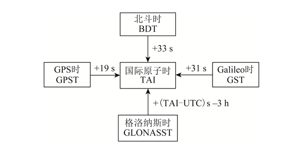
beeld1 Systeemtijdconversierelatie
4 Comparative analysis of GNSS service performance
De prestaties van satellietnavigatiesystemen omvatten nauwkeurigheid, integriteit, continuïteit en beschikbaarheid, waarbij gebruikers zich vooral zorgen maken over nauwkeurigheid en beschikbaarheid.De nauwkeurigheid van de dienstverlening omvat positioneringsnauwkeurigheid, snelheidsnauwkeurigheid en tijdsnauwkeurigheid. Positioneringsnauwkeurigheid is de statistische waarde van het verschil tussen de door de gebruiker met behulp van satellietsignalen bepaalde positie en de werkelijke positie, inclusief horizontale en verticale positioneringsnauwkeurigheid. Snelheidsnauwkeurigheid is de statistische waarde van het verschil tussen de door de gebruiker met behulp van satellietsignalen bepaalde snelheid en de werkelijke snelheid, wat over het algemeen de driedimensionale snelheidsfout in de ruimte is. Tijdsnauwkeurigheid is de statistische waarde van het verschil tussen de tijd die met behulp van satellietsignalen wordt bepaald en de tijd die door het satellietnavigatiesysteem wordt weergegeven.Service availability is the ratio of system service time to expected service time. The serviceable time is the time when the position dilution of precision (PDOP) availability and positioning availability within the specified area meet the requirements. PDOP availability is the percentage of time that the PDOP value meets the threshold requirements within a specified geographical or spatial area and time period. Positioning availability is the percentage of time that the positioning accuracy meets the threshold requirements within the specified service area and time period.De positioneringsnauwkeurigheid van het navigatiesysteem wordt hoofdzakelijk bepaald door twee factoren: ① de PDOP-waarde; ② de equivalente afstandserror van de gebruiker (UERE). UERE bestaat uit de afstandserror van de gebruiker (URE) en de fout van de gebruikersapparatuur (UEE). Hierbij geldt: URE is de som van de fouten in de afstandsmeting van de satelliet tot de gebruikersterminal, veroorzaakt door fouten in de baan van de navigatiesatelliet en de klokfout van de satelliet, en wordt hoofdzakelijk bepaald door het satellietnavigatiesysteem; UEE is de fout die wordt veroorzaakt door meerpadseffecten op de grond en lusruis in de gebruikersontvanger, enz., en wordt hoofdzakelijk bepaald door de gebruiksomgeving en het ontwerp van de lokale ontvanger.Gebaseerd op specificaties voor serviceprestaties en de meest recente officiële conferentiematerialen van BDS, GPS, Galileo en GLONASS.[3,14-17], the public service performance parameters of each global satellite navigation system were sorted out, and the results are shown in Table 5. In Table 5, RMS (root mean square) represents the root mean square.
Systeemnaam | URE/m | URRE/(m·s-1) | Positioneringsnauwkeurigheid/m bij 95% betrouwbaarheid | nauwkeurigheid van snelheidsmeting/ | 95% betrouwbaarheid | |
horizontale richting | elevation direction | |||||
BDS | B1C/B2a: 0.6 (RMS) | 0.006 (RMS) | 10 | 10 | 0.2(95%) | 20 |
B1I/B3I: 1 (RMS) | ||||||
GPS | Het resultaat bij een betrouwbaarheid van 95% is 7.8 | Het resultaat bij een betrouwbaarheid van 95% is 0.006 | 9 | 15 | 0.1 | 40 |
Galileo | Het resultaat bij een betrouwbaarheid van 95% is 7 | - | 4 | 8 | - | 30 |
GLONASS | Het resultaat bij een betrouwbaarheid van 95% is 18 | Het resultaat bij een betrouwbaarheid van 95% is 0.02 | 5 | 9 | - | 700 |
表5 GMSGeef serviceprestatieparameters bloot
In werkelijkheid zijn de gemeten prestaties van elk satellietnavigatiesysteem beter dan de beloofde prestaties voor de openbare dienstverlening. Dit blijkt uit het rapport van het Chinese Bureau voor Satellietbeheer tijdens de 14e bijeenkomst van het Internationale Comité voor Wereldwijde Navigatiesatellietsystemen (ICG) in 2019.[18], the measured horizontal positioning accuracy of BDS B1I/B3I is 3.6 m (result under 95% reliability), the altitude positioning accuracy is 6.6 m (result under 95% reliability), the speed measurement accuracy is 0.05 m/s (result under 95% reliability), and the timing accuracy is 9.8 ns (result under 95% reliability). The measured horizontal positioning accuracy of B1C/B2a is 2.4 m (95 The result under 95% reliability), the altitude positioning accuracy is 4.3 m (the result under 95% reliability), the speed measurement accuracy is 0.06 m/s (the result under 95% reliability), and the timing accuracy is 19.1 ns (the result under 95% reliability).Volgens het Nationaal Coördinatiebureau van de 14e ICG-conferentie in 2019室(Nationaal Coördinatiebureau, NCO)的报告[19]Uit de statistische resultaten van 14 november 2018 tot 13 november 2019 blijkt dat de gemiddelde URE van GPS 0.514 m is, de beste URE op één dag 0.362 m en de slechtste URE op één dag 0.666 m. Dit volgens het rapport van de European Space Agency op de 14e ICG-conferentie in 2019.[20-21]De Galileo-satelliet berekende in september 2019 een URE van 0.27 m (resultaat met een betrouwbaarheidsinterval van 95%), en de slechtste positioneringsnauwkeurigheid die in het equatoriale gebied werd gemeten, was 2.79 m (resultaat met een betrouwbaarheidsinterval van 95%).
5 Conclusie
This article makes a detailed comparison of the four existing GNSS, analyzes the constellation characteristics of the system, and points out the advantages of the BOS MEO/IGSO/GEO combined constellation; summarizes the signal system of each navigation system, highlighting the advantages of multi-system compatibility and interoperability and BDS information encoding; conducts a comparative analysis of the coordinate system and time system of each system; analyzes the service performance of the satellite navigation system,De serviceprestatieparameters van elk navigatiesysteem worden samengevat.Uit een vergelijkende analyse blijkt dat BDS, na de globalisering, beschikt over geavanceerde technologie, complete functionaliteit, uitstekende prestaties, uitstekende compatibiliteit en interoperabiliteit met GPS en Galileo, en volledig onafhankelijke intellectuele eigendomsrechten. Het bevindt zich in een fase waarin het parallel loopt met GPS, wat een belangrijke garantie biedt voor BDS om wereldwijd door te breken en de internationale standaard te worden. Aangezien het land fors blijft investeren in middelen en personeel, wordt verwacht dat BDS in de nabije toekomst een leidende rol zal spelen in de internationale GNSS-markt.
This article is reprinted from "Surveying and Mapping Academic Information" to support the protection of intellectual property rights. Please indicate the original source and author when reprinting. If there is any infringement, please contact us to delete it.
Related Recommendations