























サービスホットライン
ニュース

ニュース

世界の主要な4つの衛星航法システムに関する簡単な分析
2021-12-28
1151
4大型衛星航法システムの簡単な分析
概要: 衛星航法システムをさらに研究するために、既存の 4 つのグローバル衛星航法システム、すなわち北斗衛星航法システム (BDS)、全地球測位システム (GPS)、ガリレオ衛星航法システム (Galileo)、および GLONASS 衛星航法システム (GLONASS) の比較分析を実施し、コンステレーション、信号システム、座標および時刻システム、サービス性能の観点から比較し、BDS の利点を指摘しました。結果は、BDS がシステム コンステレーションと情報符号化において大きな利点を持ち、システム サービス性能は GPS および Galileo と同等であり、GLONASS よりも優れていることを示しています。BDS は、静止軌道 (GEO)、傾斜静止軌道 (IGSO)、および中間圏地球軌道 (MEO) のコンステレーション分布に基づいており、アジア太平洋地域での測位精度と可用性を向上させることができます。BDS で使用されている 64 ベース低密度パリティチェック (LDPC) 符号化は、他のシステムの符号化方法よりも優れています。 GPSのバイナリLDPC符号化と比較すると、0.6~1.2dBの追加利得が得られる。
Keywords: global satellite navigation system; system constellation; signal system; coordinate system; system time; service performance
0 誘導
現在、4つの大全球卫星导航航システム统(全地球航法衛星システム、GNSS)、中国の北斗卫星导航航システム统(BeiDouナビゲーション衛星システム、BDS)、米国の全球測位システム统(全地球測位システム、GPS)、欧州同盟の伽利略卫星导航航システム统(ガリレオ航法衛星システム、その中で、BDS と GPS は全球に相当する性能を備えており、BDS は GPS の多領域短文および全球短文機能に匹敵します。GLONASSは世界中で運用されているものの、その性能はBDSやGPSに比べてやや劣り、軌道傾斜角が大きいため低緯度地域では性能が低下する。ガリレオの観測精度は優れているものの、衛星時計の安定性がやや劣るため、システムの信頼性が低い。
GNSS is mainly composed of space segment, ground segment and user segment. Its working principle次のように:
1) The navigation satellites distributed according to the constellation in the space segment receive clock correction, ephemeris and other information injected uplink from the ground segment for signal modulation, and broadcast signals to the ground according to the prescribed signal system.
2) 地上セグメントは、宇宙衛星を追跡および維持し、衛星の状態を監視し、衛星と信号の完全性を評価し、衛星の軌道を決定し、衛星のクロック補正、暦、アルマナック、電離層補正パラメータ、およびその他の情報を特定の周波数で衛星にアップリンクします。
3) The user segment receives signals from each visible satellite, and performs position, velocity, and time (PVT) calculations based on the observations obtained from the tracking signal and the ephemeris and time information obtained from the demodulated signal to determine the user's position, velocity, and time information.航法システムの宇宙セグメントは、主に2つの重要な特徴を備えています。
① 衛星の空間分布を表す宇宙コンステレーション。
②Characteristics of satellite broadcast signals. As far as the entire system is concerned, what users are most concerned about is its service performance. This article mainly compares the space constellation, signal system, coordinate and time system and service performance of GNSS, and analyzes the characteristics of BDS on this basis.
1 Comparative analysis of GNSS constellations
The elements of a satellite navigation system space constellation mainly include constellation type, satellite type, number of satellites, orbital altitude, orbital inclination, etc. The constellation distribution of GPS, Galileo and GLONASS is roughly the same, and the satellites are all medium Earth orbit (MEO) satellites. The BDS constellation includes MEO satellites, inclined geosynchronous orbit (IGSO) satellites and geostationary orbit (GEO) satellites. BDS's three GEO satellites are located above the equator, respectively distributed at 80°E, 110.5°E and 140°E. BDS’s three IGSO satellites are distributed in three orbital planes【3]BDSの24基の中軌道衛星は3つの軌道面に均等に配置されており、その衛星直下点軌道は世界中をカバーしています。MEO/IGSO/GEOのコンステレーション配置により、BDSはアジア太平洋地域におけるBDS衛星の視認性を大幅に向上させ、それによってBDSの測位精度と可用性を向上させることができます。
衛星ナビゲーションシステム名 | さまざまな衛星ナビゲーションシステムのナビゲーション衛星パラメータ | |||||||
星座の種類 | 衛星 | Number of different types of satellites | 衛星の軌道高度(km)の種類 | different types of satellites | different types of satellites | トラック路面 | 星座分布繰り返し周期 (times/day) | |
BDS | MEOの星座はウォーカー型24/3/1である。 | ジオ IGSO MEO | 3 3 24 | 35 786 35 786 21 528 | - 55 55 | - 23時間56分4秒 12 55時間分 | - - 3 | 13/7 (7日間で13回繰り返す) |
GPS | ウォーカー星座以外の星座 | MEO | 24 | 20 200 | 55 | 11 58時間分 | 6 | 2/1 (1日2回繰り返してください) |
ガリレオ | ウォーカー型星座24/3/1 | MEO | 24 | 23 222 | 56 | 14時間4分45秒 | 3 | 17/10 (10日間で17回繰り返す) |
GLONASS | ウォーカー型星座 24/3/2 | MEO | 24 | 19 100 | 64.8 | 11時間15分44秒 | 3 | 17/8 (8日間で17回繰り返す) |
表1 Global satellite navigation system space constellation comparison
2. GNSSシステムの比較分析
4つの主要な衛星航法システムはそれぞれ独自の特性を持っています。マルチアクセス方式に関しては、BDS、GPS、Galileoのマルチアクセス方式は符号分割多重アクセス(CDMA)です。GLONASSのマルチアクセス方式は現在周波数分割多重アクセス(FDMA)ですが、近代化計画ではCDMAへの移行を目指しています。信号コンポーネントに関しては、特別な用途向けの認可済みまたは独自の信号コンポーネントを除いて、BDS、GPS、Galileoは一定期間の研究と調整を経て、民間公共信号に関する互換性と相互運用性を備えた協力協定が締結され、BDS B1CおよびB2aとGPS L1、L5、Galileo E1およびE5aとの相互運用性が実現しました。これにより、衛星航法システムのサービス性能が大幅に向上し、マルチシステムユーザー端末の開発コストを削減できます。表2は、主に信号周波数、信号分岐、変調方式、情報符号化方式、シンボルレート、信号帯域幅といった観点から、4つの主要な衛星航法信号システムを比較分析しており、読者が各システムの信号について包括的かつ体系的に理解できるようになっています。
システム名 | シグナル | シグナル | Carrier frequency/MHz | 変調方式 | Information encoding method | シンボルレート(秒当たり) "sampling times") | main lobe band | 放送衛星タイプ |
BDS | B1I | I road | 1 561.098 | BPSK(2) | BCH(15,11,1)+interleaved | 50 | 2.046 0 | 地理情報システム/地理情報システム |
B1C | B1C_データ | 1 575.420 | ボリウッド(1,1) | BCH(21,6)+BCH(51,8)+64进制LDPC(200,100)+64进制LDPC(88,44)+交织 | 100 | 32.736 0 | IGSO/MEO | |
B1C_パイロット | QMBOC(6,1,4/33) | - | 0 | |||||
B2a | B2a_データ | 1 176.450 | QPSK(10) | 64進LDPC(96,48) | 200 | 20.460 0 | IGSO/MEO | |
B2aパイロット | - | 0 | ||||||
B2b | I road | 1 207.140 | QPSK(10) | 64進LDPC(162,81) | 1000 | 20.460 0 | IGSO/MEO | |
B3I | I road | 1 268.520 | QPSK(10) | BCH(15,11,1)+interleaved | 50 | 20.460 0 | 地理情報システム/地理情報システム | |
GPS | L1 | 会計 | 1 575.420 | BPSK(1) | ハミングコード (32,26) | 50 | 2.046 0 | MEO |
P(Y) | BPSK(10) | 暗号化 | 50 | 20.460 0 | ||||
M | ボリウッド(10,5) | 暗号化 | - | 30.690 0 | ||||
L1C | L1C-D | 1 575.420 | ボリウッド(1,1) | CRC-24Q+BCH(51,8)+バイナリLDPC(1200,600)+ブロックインターリーブ | 100 | 4.092 0 | MEO | |
L1C-P | TMBOC(6、1、4/33) | - | - | 14.332 0 | ||||
L2 | P(Y) | 1 227.600 | BPSK(10) | 暗号化 | 50 | 20.460 0 | MEO | |
C | BPSK(1) | CRC-24Q+ convolutional encoding (600,300) | 50 | 2.046 0 | ||||
M | ボリウッド(10,5) | 暗号化 | - | 30.690 0 | ||||
L5 | L5C | 1 176.450 | QPSK(10) | CRC-24Q+ convolutional encoding (600,300) | 100 | 20.460 0 | MEO | |
L5Q | 暗号化 | - | ||||||
ガリレオ | E1 | E1-A | 1 575.420 | BOCCOS(15,2.5) | 暗号化 | 100 | 35.805 0 | MEO |
E1-B | CBOC(6,1,1/11,'+') | CRC-24Q + convolutional encoding (240,120) + interleaving | 4.092 0 | |||||
E1-C | CBOC(6,1,1/11,'+') | - | 4.092 0 | |||||
E5a | E5a-I | 1 176.450 | オルトBOC(15,10) | CRC-24Q + convolutional encoding (488,244) + interleaving | 50 | 51.150 0 | MEO | |
E5b | E5b-I | 1 207.140 | CRC-24Q + convolutional encoding (240,120) + interleaving | 250 | ||||
E6 | E6-A | 1 278.750 | BOCCOS(10,5) | 暗号化 | 100 | 30.690 0 | MEO | |
E6-B | BPSK(5) | 暗号化 | 1000 | 10.230 0 | ||||
E6-C | BPSK(5) | - | - | 10.230 0 | ||||
GLONASS | G1 | 1 598.0 625~1 605.375 | BPSK | ハミングコード | 100 | 8.334 5 | MEO | |
G2 | 1 242.9 375~1 248.625 | BPSK | ハミングコード | 100 | 6.709 5 | |||
表2 GNSSシグナル伝達システムの比較[4-9]
表2中:BPSK(二相位相偏移変調)は二相位相制御を表す;QMBOC(直交多重化バイナリオフセットキャリア)は正交用二乗偏移波制御を表す;TMBOC(時間多重化バイナリオフセットキャリア)は時間分割用二相制御を表す;CBOC(複合バイナリオフセット)キャリア)は多重二重化オフセット搬送波を表し、BCH(Bose Chaudhuri Hocquenghem)はBose、Chaudhuri、Hocquendhem がそれぞれ独立して発行した二元性サイクルコードを表し、CRC(巡回冗長検査)は循環冗長チェックを表します。表2からわかるように、BDSのB1C信号、GPSのL1C信号、GalileoのE1信号は1575.42MHzで動作し、デバッグ方式はバイナリオフセットキャリア(BOC)型変調です。BDSのB2a信号、GPSのL5信号、GalileoのE5a信号は1176.45MHzで動作し、B2aとL5は四相位相シフトキーイング(QPSK)変調方式、E5aは交互バイナリオフセットキャリア(AltBOC)変調方式です。周波数の一貫性と変調方式の類似性は、GNSSの互換性と相互運用性の前提条件となります。現在、1575.42MHzでは互換性と相互運用性が非常に良好に実現されています。航法メッセージ設計に関して、BDSは航法メッセージ符号化の重要な特徴として64ベース低密度パリティチェック(LDPC)符号化を導入しました。その符号化および復号化方式は中国が独自に開発したもので、GPSのバイナリLDPC符号化と比較して性能が大幅に向上しています。64ベースLDPC符号化とバイナリLDPC符号化の複雑さは基本的に同じですが、復号化に関しては、64ベース復号化の複雑さはバイナリ復号化の約6倍です。ビット誤り率は1×10⁻⁶です。-5この条件下では、64値LDPC符号化の利得は2値LDPC符号化の利得よりも0.6~1.2dB高く、ユーザ端末のコールドスタート関連指標の改善に大きなメリットをもたらします。。
3. GNSS座標系と時刻系の比較分析
3.1 Comparative analysis of coordinate systems
The coordinate system of the satellite navigation system is particularly important. The satellite position and satellite speed calculated from the satellite ephemeris parameters and almanac parameters are directly represented in the system coordinate system. The system coordinate system defines the datum ellipsoid required to establish the corresponding geodetic coordinate system, describes the Earth's gravity field model corresponding to the geoid, and provides corrected basic geodetic parameters. The corrected basic geodetic parameters of each system are shown in Table 3.
システム名 | 座標系名 | 座標系パラメータ | |||
Ellipsoid length/m | 扁平 | gravitational constant/ | 地球の自転角速度/ | ||
BDS | BDCS | 6 378 137.00 | 1 / 298.257 222 101 | 3.986 004 418 | 7.292 115 |
GPS | WGS84 | 6 378 137.00 | 1 / 298.257 223 563 | 3.986 004 418 | 7.292 115 |
ガリレオ | GTRF | 6 378 136.55 | 1 / 298.257 690 000 | 3.986 004 418 | 7.292 115 146 7 |
GLONASS | PZ90 | 6 378 136.00 | 1 / 298.257 839 303 | 3.986 004 418 | 7.292 115 |
表3 各座標系の基本測地パラメータ[4-9]
北斗座標系(BDCS)は、地球中心の地球基準系です。BDCSの定義は、国際地球回転サービス(IERS)仕様に準拠し、中国測地座標系2000(CGCS2000)の基準楕円体パラメータを使用します。CGCS2000との主な違いは更新頻度です。BDCSはBDS専用の座標系であり、1年または半年に1回更新できます。CGCS2000は、相関範囲が広く、更新間隔が長い国家座標系です。BDCSの実装は、最新の国際地球基準フレーム(ITRF)に整合されます。WGS84(世界測地系84)は、米国のGPSで使用される測地座標系です。GTRF(ガリレオ地球基準フレーム)は、EUのガリレオで使用される測地座標系です。PZ-90(PZ-90測地系)は、ロシアによって確立された測地座標系です。
3.2 時間システムの比較分析
The time system is the core of the satellite navigation system and the cornerstone of the normal operation of the satellite navigation system. BDS, GPS and Galileo have all established dedicated time systems based on atomic time (AT). Their second lengths are synthesized based on the observations of atomic clocks and satellite atomic clocks installed on their ground monitoring stations. They are still essentially atomic time and therefore continuous, without the need for leap seconds like coordinated universal time. GLONASS system time (GLONASST) is different from the other three system times. It is an atomic time system similar to coordinated universal time (UTC). It introduces leap seconds during operation, uses Moscow time as the benchmark, and traces its origin to the coordinated universal time UTC (SU) maintained by the Russian Institute of Time Metrology.北斗衛星測位システム(BDT)の時刻は、BDSマスター制御局によって生成および維持され、米国国家時間サービスセンターが管理する協定世界時(NTSC)にトレーサブルです。GPS時刻(GPS時刻、GPST)は、GPSマスター制御局によって生成および維持され、米国海軍天文台が管理する協定世界時(UTC)(USNO)にトレーサブルです。【12]ガリレオ時間(ガリレオ時間、GST)は、国の計量局(国際度量衡局、BIPM)に保持されている変動世界時間 UTC(BIPM)から直接取得されます。国際原子時(TAI)は原子秒で計測され、1958年1月1日の世界時(UT)0:00から累積されます。この時点では、世界時と国際原子時の差はゼロであり、その後年々増加していきます。1972年、国際原子時と世界時の差を調和させるために、妥協案として協定世界時が提案されました。協定世界時は、正確なTAIの秒長に基づいています。TAIと世界時の差が0.9秒を超えると、1秒の閏秒が人為的に追加され、世界時と協定世界時の差が常に0.9秒以内になるようにします。【13]. The system time comparison of the four major satellite navigation systems is shown in Table 4.
衛星航法 | さまざまな衛星ナビゲーションシステムの時間システムパラメータ | |||
時間システム名 | 開始時期 | それは連続的なものですか? | ラグTAI時間/秒 | |
BDS | BDT | 2006-01-01 00:00:00(UTC) | はい | 33 |
GPS | GPST の | 1980-01-06 00:00:00(UTC) | はい | 19 |
ガリレオ | GST | 1999-08-22 00:00:00(UTC)前13 s | はい | 19 |
GLONASS | グロナスト | UTC(SU) 3時間遅れ | いいえ | うるう秒による変更 |
表4 GNSS時間システムの比較
According to comparative analysis, the starting epoch of GST is set to 13 seconds before 1999-08-22T 00:00:00 (UTC) in order to be consistent with GPST. Both GST and GPST lag TAI by 19 seconds.
各システム時間間の変換関係を図1に示す。
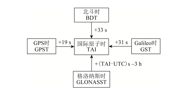
画像1 システム時間変換関係
4. GNSSサービス性能の比較分析
衛星航法システムのサービス性能には、精度、完全性、継続性、可用性が含まれるが、ユーザーが最も重視するのは精度と可用性である。サービス精度には、測位精度、速度測定精度、および時間測定精度が含まれます。測位精度とは、ユーザーが衛星信号を使用して決定した位置と実際の位置との差の統計値であり、水平測位精度と垂直測位精度が含まれます。速度測定精度とは、ユーザーが衛星信号を使用して決定した速度と実際の速度との差の統計値であり、一般的には三次元空間速度誤差です。時間測定精度とは、衛星信号を使用して決定した時間と衛星航法システムの時間との差の統計値です。サービス可用性とは、システムサービス時間と期待サービス時間の比率です。サービス可能時間とは、指定エリア内の位置精度低下率(PDOP)可用性と測位可用性が要件を満たす時間のことです。PDOP可用性とは、指定された地理的または空間的エリアおよび期間内でPDOP値がしきい値要件を満たす時間の割合です。測位可用性とは、指定されたサービスエリアおよび期間内で測位精度がしきい値要件を満たす時間の割合です。The positioning accuracy of the navigation system is mainly determined by two factors: ① PDOP value; ② user equivalent range error (UERE). UERE consists of user range error (URE) and user equipment error (UEE). Among them: URE is the sum of errors in the distance observation from the satellite to the user terminal caused by errors in the navigation satellite orbit and satellite clock error, which is mainly determined by the satellite navigation system; UEE is the error caused by ground multipath effects and user receiver loop noise, etc., which is mainly determined by the use environment and the design of the local receiver.BDS、GPS、Galileo、GLONASSのサービス性能仕様および最新の公式会議資料に基づく[3,14-17]各グローバル衛星航法システムの公共サービス性能パラメータを整理し、結果を表5に示します。表5では、RMS(二乗平均平方根)は二乗平均平方根を表します。
システム名 | URE/m | URRE/(m·s-1) | Positioning accuracy/m at 95% reliability | Speed measurement accuracy/ | 95%の信頼性 | |
水平方向 | 仰角方向 | |||||
BDS | B1C/B2a:0.6(実効値) | 0.006(実効値) | 10 | 10 | 0.2(95%) | 20 |
B1I/B3I:1(RMS) | ||||||
GPS | 95%の信頼性での結果は7.8です | 95%の信頼性での結果は0.006です | 9 | 15 | 0.1 | 40 |
ガリレオ | 95%の信頼性での結果は7です | - | 4 | 8 | - | 30 |
GLONASS | 95%の信頼性での結果は18です | 95%の信頼性での結果は0.02です | 5 | 9 | - | 700 |
表5 GMSSサービスパフォーマンスパラメータを公開する
In fact, the measured performance of each satellite navigation system is better than the promised public service performance. According to the report of the China Satellite Management Office at the 14th International Committee on Global Navigation Satellite System (ICG) meeting in 2019【18]測定された BDS B1I/B3I の水平位置精度は 3.6 m (信頼度 95% 未満)、高度位置精度は 6.6 m (信頼度 95% 未満)、速度測定精度は 0.05 m/s (信頼度 95% 未満)、タイミング精度は 9.8 ns (信頼度 95% 未満) です。測定された B1C/B2a の水平位置精度は 2.4 m (信頼度 95% 未満)、高度位置精度は 4.3 m (信頼度 95% 未満)、速度測定精度は 0.06 m/s (信頼度 95% 未満)、タイミング精度は 19.1 ns (信頼度 95% 未満) です。According to the National Coordination Office of the 14th ICG Conference in 2019室(国家調整局、下士官)の报告【19]2018年11月14日から2019年11月13日までの統計結果によると、GPSの平均UREは0.514m、最良日のUREは0.362m、最悪日のUREは0.666mである。2019年の第14回ICG会議における欧州宇宙機関の報告によると[20-21], the Galileo satellite URE calculated in September 2019 was 0.27 m (result under 95% reliability), and the worst positioning accuracy monitored in the equatorial region was 2.79 m (result under 95% reliability).
5まとめ
本稿では、既存の4つのGNSSを詳細に比較し、システムのコンステレーション特性を分析し、BOS MEO/IGSO/GEO複合コンステレーションの利点を指摘する。各ナビゲーションシステムの信号システムを要約し、マルチシステム互換性と相互運用性、およびBDS情報エンコーディングの利点を強調する。各システムの座標系と時間システムの比較分析を行い、衛星ナビゲーションシステムのサービス性能を分析する。各ナビゲーションシステムのサービスパフォーマンスパラメータをまとめます。Through comparative analysis, it can be seen that after the globalization of BDS, it has advanced technology, complete functions, excellent performance, excellent compatibility and interoperability with GPS and Galileo, and has completely independent intellectual property rights. It is in the stage of running alongside GPS, which provides an important guarantee for BDS to go global and become the international mainstream. As the country continues to invest heavily in resources and manpower, it is expected that BDS will lead foreign GNSS in the near future.
本記事は、知的財産権の保護を目的として、『学術情報の調査とマッピング』から転載したものです。転載の際は、出典と著者名を明記してください。著作権侵害が疑われる場合は、ご連絡いただければ削除いたします。
関連おすすめ
Kinghelm 営業副部長の彭慧生:深圳に住む客家出身者、努力を通じて当初の志を貫く
2026-08-03
2243
ソン・シチャンが語る戦略:2026年エレクトロニカ上海対話のハイライト
2026-07-21
2447
清華大学の情熱: 材料科学における課題の克服 – CEN寧波金山新材料会社のCen Jianjun氏へのインタビュー
2026-07-14
2624
大胆なビジョン、勇敢な行動、次の波に乗るのはあなたかもしれない!―嘉正新城創業者、謝維新氏へのインタビュー
2026-06-30
2846