























서비스 핫라인
뉴스

뉴스

세계 4대 위성항법시스템에 대한 간략한 분석
2021-12-28
1151
전세계적인4A brief analysis of large satellite navigation systems
요약: 위성항법 시스템에 대한 심층적인 연구를 위해, 현재 사용 중인 4대 글로벌 위성항법 시스템인 베이더우 위성항법시스템(BDS), GPS(Global Positioning System), 갈릴레오 위성항법시스템(Galileo), 그리고 GLONASS(Global Localization System)를 위성군 구성, 신호 체계, 좌표 및 시간 체계, 서비스 성능 측면에서 비교 분석하였다. 분석 결과, BDS는 위성군 구성 및 정보 인코딩 측면에서 큰 장점을 가지며, 서비스 성능은 GPS 및 갈릴레오와 동등하고 GLONASS보다 우수함을 보여주었다. BDS는 정지궤도(GEO), 경사 정지궤도(IGSO), 그리고 중간권(MEO) 등 다양한 궤도를 활용하여 아시아 태평양 지역에서 위치 정확도와 가용성을 향상시켰다. 또한, BDS에서 사용하는 64진수 저밀도 패리티 검사(LDPC) 인코딩 방식은 다른 시스템들의 인코딩 방식보다 우수한 성능을 보였다. GPS의 이진 LDPC 인코딩 방식과 비교했을 때, 0.6~1.2dB의 추가적인 이득을 가져올 수 있습니다.
핵심어: 글로벌 위성항법시스템; 시스템 구성; 신호 시스템; 좌표계; 시스템 시간; 서비스 성능
0 답변
目前有4大全球卫星导航系统(세계항법위성시스템, GNSS), 包括中國的北斗卫星导航系统(BeiDou 항법위성시스템, BDS), 미국적 전체球定位系统(지구위치확인시스템, GPS), 欧盟的伽利略卫별导航系统(Galileo 항법 위성 시스템, Galileo) 및 俄罗斯的格洛纳斯卫Stars导航系统(지구 궤도 항법 위성 시스템, GLONASS)。其中,BDS와GPS已服务全球,性能当;功能方face,BDS较GPS多了区域短报文球短报文功能GLONASS는 전 세계적으로 사용되고 있지만, 성능은 BDS와 GPS에 비해 다소 떨어지며, GLONASS 궤도의 경사각이 커서 저위도 지역에서 성능이 저하됩니다. 갈릴레오 탐사선의 관측 품질은 더 우수하지만, 위성 시계의 안정성이 다소 떨어져 시스템 신뢰성이 저하됩니다.
GNSS는 주로 우주 부분, 지상 부분 및 사용자 부분으로 구성됩니다. GNSS의 작동 원리는 다음과 같습니다.다음과 같이 :
1) The navigation satellites distributed according to the constellation in the space segment receive clock correction, ephemeris and other information injected uplink from the ground segment for signal modulation, and broadcast signals to the ground according to the prescribed signal system.
2) 지상 관제 시스템은 우주 위성을 추적 및 유지 관리하고, 위성의 상태를 모니터링하고, 위성과 신호의 무결성을 평가하고, 위성의 궤도를 결정하고, 위성의 시계 보정, 천체력, 천문력, 전리층 보정 매개변수 및 기타 정보를 특정 주파수로 위성에 전송합니다.
3) 사용자 부분은 각 가시 위성으로부터 신호를 수신하고, 추적 신호에서 얻은 관측값과 복조된 신호에서 얻은 천체력 및 시간 정보를 기반으로 위치, 속도 및 시간(PVT) 계산을 수행하여 사용자의 위치, 속도 및 시간 정보를 결정합니다.The navigation system space segment mainly includes two important characteristics:
① 위성의 공간적 분포를 나타내는 우주 별자리;
②위성 방송 신호의 특성. 전체 시스템과 관련하여 사용자가 가장 중요하게 생각하는 것은 서비스 성능입니다. 본 논문에서는 주로 GNSS의 위성군, 신호 체계, 좌표 및 시간 체계, 서비스 성능을 비교하고 이를 바탕으로 BDS의 특성을 분석합니다.
1. GNSS 위성군에 대한 비교 분석
위성항법시스템(GPS) 위성군의 구성 요소는 주로 위성군 유형, 위성 유형, 위성 수, 궤도 고도, 궤도 경사각 등을 포함합니다. GPS, Galileo, GLONASS의 위성군 분포는 대체로 유사하며, 모든 위성은 중궤도(MEO) 위성입니다. BDS 위성군은 MEO 위성, 경사 정지궤도(IGSO) 위성, 정지궤도(GEO) 위성으로 구성됩니다. BDS의 세 개의 GEO 위성은 적도 상공에 각각 동경 80°, 110.5°, 140°에 위치하고 있습니다. BDS의 세 개의 IGSO 위성은 세 개의 궤도면에 분포되어 있습니다.[3]. BDS's 24 MEO satellites are evenly distributed in three orbital planes, and their subsatellite point trajectories cover the world. Through the MEO/IGSO/GEO constellation layout, BDS can greatly improve the visibility of BDS satellites in the Asia-Pacific region, thereby improving the positioning accuracy and availability of BDS.
위성 항법 시스템 이름 | 다양한 위성 항법 시스템의 항법 위성 매개변수 | |||||||
별자리 유형 | 위성 | Number of different types of satellites | Different types of satellite orbit heights/km | 다양한 유형의 위성 | 다양한 유형의 위성 | track surface | 별자리 분포 반복 주기 (하루에 횟수) | |
BDS | MEO의 별자리는 워커형 24/3/1입니다. | GEO IGSO MEO | 3 3 24 | 35 786 35 786 21 528 | - 55 55 | - 23시간 56분 4초 12 55의 시간 분 | - - 3 | 13/7 (Repeat 13 times in 7 days) |
GPS | 비워커 별자리 | MEO | 24 | 20 200 | 55 | 11 58의 시간 분 | 6 | 2/1 (Repeat 2 times a day) |
갈릴레오 | 워커형 별장 24/3/1 | MEO | 24 | 23 222 | 56 | 14시간 4분 45초 | 3 | 17/10 (Repeat 17 times in 10 days) |
GLONASS | 워커형 별장 24/3/2 | MEO | 24 | 19 100 | 64.8 | 11시간 15분 44초 | 3 | 17/8 (Repeat 17 times in 8 days) |
表1 Global satellite navigation system space constellation comparison
2 Comparative analysis of GNSS systems
Each of the four major satellite navigation systems has its own characteristics. As for the multi-access mechanism, the multi-access mechanism of BDS, GPS and Galileo is code division multiple access (CDMA). The multi-access mechanism of GLONASS is currently frequency division multiple access (FDMA). Its modernization plan is to develop towards CDMA. As far as signal components are concerned, in addition to some authorized or proprietary signal components for special purposes, BDS, GPS and Galileo have연구 및 협의 기간을 거쳐 민간 공공 신호에 대한 호환 및 상호 운용 가능한 협력 협정이 체결되었으며, 이를 통해 BDS B1C 및 B2a와 GPS L1, L5, Galileo E1 및 E5a 간의 상호 운용성이 실현되었습니다. 이는 위성 항법 시스템의 서비스 성능을 크게 향상시키고 다중 시스템 사용자 단말기의 개발 비용을 절감할 수 있습니다.Table 2 mainly compares and analyzes the four major satellite navigation signal systems from the aspects of signal frequency, signal branch, modulation method, information encoding method, symbol rate and signal bandwidth, so that readers can have a comprehensive and systematic understanding of the signals of each system.
시스템 이름 | 신호 | 신호 | 반송파 주파수/MHz | 변조 방식 | 정보 인코딩 방법 | 심볼 전송률(초당) "샘플링 시간" | 주엽대 | 방송위성형 |
BDS | B1I | I road | 1 561.098 | BPSK(2) | BCH(15,11,1)+인터리브드 | 50 | 2.046 0 | 지리/IGSO/MEO |
B1C | B1C_데이터 | 1 575.420 | BOC(1,1) | BCH(21,6)+BCH(51,8)+64进制LDPC(200,100)+64进制LDPC(88,44)+交织 | 100 | 32.736 0 | IGSO/MEO | |
B1C_파일럿 | QMBOC(6,1,4/33) | - | 0 | |||||
B2a | B2a_데이터 | 1 176.450 | QPSK(10) | 64측 LDPC(96,48) | 200 | 20.460 0 | IGSO/MEO | |
B2a_파일럿 | - | 0 | ||||||
B2B | I road | 1 207.140 | QPSK(10) | 64측 LDPC(162,81) | 1000 | 20.460 0 | IGSO/MEO | |
B3I | I road | 1 268.520 | QPSK(10) | BCH(15,11,1)+인터리브드 | 50 | 20.460 0 | 지리/IGSO/MEO | |
GPS | L1 | C/A | 1 575.420 | BPSK(1) | 해밍 코드(32,26) | 50 | 2.046 0 | MEO |
피(Y) | BPSK(10) | 암호화 | 50 | 20.460 0 | ||||
M | BOC(10,5) | 암호화 | - | 30.690 0 | ||||
L1C | L1C-D | 1 575.420 | BOC(1,1) | CRC-24Q+BCH(51,8)+이진 LDPC(1200,600)+블록 인터리빙 | 100 | 4.092 0 | MEO | |
L1C-P | TMBOC(6,1,4/33) | - | - | 14.332 0 | ||||
L2 | 피(Y) | 1 227.600 | BPSK(10) | 암호화 | 50 | 20.460 0 | MEO | |
C | BPSK(1) | CRC-24Q+ 컨볼루션 인코딩(600,300) | 50 | 2.046 0 | ||||
M | BOC(10,5) | 암호화 | - | 30.690 0 | ||||
L5 | L5C | 1 176.450 | QPSK(10) | CRC-24Q+ 컨볼루션 인코딩(600,300) | 100 | 20.460 0 | MEO | |
L5Q | 암호화 | - | ||||||
갈릴레오 | E1 | E1-A | 1 575.420 | BOCCOS(15,2.5) | 암호화 | 100 | 35.805 0 | MEO |
E1-B | CBOC(6,1,1/11,'+') | CRC-24Q + 컨볼루션 인코딩(240,120) + 인터리빙 | 4.092 0 | |||||
E1-C | CBOC(6,1,1/11,'+') | - | 4.092 0 | |||||
E5a | E5a-I | 1 176.450 | AltBOC(15,10) | CRC-24Q + 컨볼루션 인코딩(488,244) + 인터리빙 | 50 | 51.150 0 | MEO | |
E5b | E5b-I | 1 207.140 | CRC-24Q + 컨볼루션 인코딩(240,120) + 인터리빙 | 250 | ||||
E6 | E6-A | 1 278.750 | BOCCOS(10,5) | 암호화 | 100 | 30.690 0 | MEO | |
E6-B | BPSK(5) | 암호화 | 1000 | 10.230 0 | ||||
E6-C | BPSK(5) | - | - | 10.230 0 | ||||
GLONASS | G1 | 1 598.0 625~1 605.375 | BPSK | 해밍 코드 | 100 | 8.334 5 | MEO | |
G2 | 1 242.9 375~1 248.625 | BPSK | 해밍 코드 | 100 | 6.709 5 | |||
表2 GNSSComparison of signaling systems[4-9]
表2中:BPSK(바이너리 위상 편이 키잉) 表示二交时分复用XNUMX进 제어 장치 偏移载波;CBOC(복합 바이너리 오프셋 캐리어)表示复합이장치제偏移载波;BCH(Bose Chaudhuri Hocquenghem)表示Bose, Chaudhuri及Hocquendhem은 자동으로 XNUMX원线性循环码; CRC(Cyclic Redundancy Check)表示循环冗余校验.As can be seen from Table 2, the B1C signal of BDS, the L1C signal of GPS and the E1 signal of Galileo work at 1 575.42 MHz, and the debugging method is binary offset carrier (BOC) type modulation; the B2a signal of BDS, the L5 signal of GPS and the E5a signal of Galileo work at 1 176.45 MHz, where B2a and L5 are quadrature phase shift keying (QPSK) modulation methods, and E5a is alternating binary offset carrier (AltBOC) modulation method. The consistency of frequencies and the similarity of modulation methods create prerequisites for GNSS compatibility and interoperability. Currently, compatibility and interoperability can be achieved very well at 1 575.42 MHz.항법 메시지 설계 측면에서 BDS는 64진수 저밀도 패리티 검사(LDPC) 인코딩을 항법 메시지 인코딩의 중요한 특징으로 도입했습니다. 이 인코딩 및 디코딩 방식은 중국에서 독자적으로 개발되었으며, GPS의 이진 LDPC 인코딩에 비해 성능이 크게 향상되었습니다. 64진수 LDPC 인코딩과 이진 LDPC 인코딩의 복잡도는 기본적으로 동일하지만, 디코딩 측면에서는 64진수 디코딩의 복잡도가 이진 디코딩의 약 6배입니다. 비트 오류율은 1×10⁻⁶입니다.-5이러한 조건에서 64진 LDPC 코딩 이득은 이진 LDPC 코딩 이득보다 0.6~1.2dB 더 높으므로 사용자 단말기의 콜드 스타트 관련 지표 개선에 상당한 이점을 제공합니다..
3. GNSS 좌표계와 시간 체계의 비교 분석
3.1 좌표계의 비교 분석
위성항법시스템의 좌표계는 특히 중요합니다. 위성 천체력 매개변수와 천체력 매개변수로부터 계산된 위성의 위치와 속도는 시스템 좌표계에 직접 표현됩니다. 시스템 좌표계는 상응하는 측지 좌표계를 설정하는 데 필요한 기준 타원체를 정의하고, 지오이드에 대응하는 지구 중력장 모델을 설명하며, 보정된 기본 측지 매개변수를 제공합니다. 각 시스템의 보정된 기본 측지 매개변수는 표 3에 나와 있습니다.
시스템 이름 | 좌표계 이름 | 좌표계 매개변수 | |||
Ellipsoid length/m | 편평도 | gravitational constant/ | Earth's rotation angular velocity/ | ||
BDS | BDCS | + 6 378 137.00 | 1 / 298.257 222 101 | + 3.986 004 418 | 7.292 115 |
GPS | WGS84 | + 6 378 137.00 | 1 / 298.257 223 563 | + 3.986 004 418 | 7.292 115 |
갈릴레오 | GTRF | + 6 378 136.55 | 1 / 298.257 690 000 | + 3.986 004 418 | 7.292 115 146 7 |
GLONASS | PZ90 | + 6 378 136.00 | 1 / 298.257 839 303 | + 3.986 004 418 | 7.292 115 |
表3 각 좌표계의 기본 측지 매개변수[4-9]
베이더우 좌표계(BDCS)는 지구 중심 좌표계입니다. BDCS는 국제 지구 자전 서비스(IERS) 규격을 준수하며, 중국 측지 좌표계 2000(CGCS2000)의 기준 타원체 매개변수를 사용합니다. CGCS2000과의 주요 차이점은 업데이트 빈도입니다. BDCS는 베이더우 위성 시스템(BDS) 전용 좌표계로, 1년에 한 번 또는 반년에 한 번 업데이트될 수 있습니다. 반면 CGCS2000은 광범위한 상관관계를 가지며 업데이트 주기가 긴 국가 좌표계입니다. BDCS 구현은 최신 국제 지상 기준계(ITRF)에 맞춰 조정될 예정입니다. WGS84(세계 측지 시스템 84)는 미국 GPS에서 사용하는 측지 좌표계이고, GTRF(갈릴레오 지상 기준계)는 EU 갈릴레오에서 사용하는 측지 좌표계이며, PZ-90(PZ-90 측지 시스템)은 러시아에서 개발한 측지 좌표계입니다.
3.2 Comparative analysis of time systems
The time system is the core of the satellite navigation system and the cornerstone of the normal operation of the satellite navigation system. BDS, GPS and Galileo have all established dedicated time systems based on atomic time (AT). Their second lengths are synthesized based on the observations of atomic clocks and satellite atomic clocks installed on their ground monitoring stations. They are still essentially atomic time and therefore continuous, without the need for leap seconds like coordinated universal time. GLONASS system time (GLONASST) is different from the other three system times. It is an atomic time system similar to coordinated universal time (UTC). It introduces leap seconds during operation, uses Moscow time as the benchmark, and traces its origin to the coordinated universal time UTC (SU) maintained by the Russian Institute of Time Metrology.BeiDou time (BDT) is generated and maintained by the BDS master control station, and is traceable to Coordinated Universal Time (NTSC) maintained by the National Time Service Center. GPS time (GPS time, GPST) is generated and maintained by the GPS master control station and is traceable to Coordinated Universal Time UTC (USNO) maintained by the U.S. Naval Observatory.[12]。Galileo时(Galileo time, GST)直接溯源到國际计weight局(International Bureau of Weights and Measures, BIPM)保持的协调世界时UTC(BIPM)。국제원자시(TAI)는 원자초 단위로 측정되며, 1958년 1월 1일 0시(UT)를 기준으로 누적됩니다. 이 시점부터 세계시와 국제원자시의 차이는 0이며, 이후 매년 증가합니다. 1972년, 국제원자시와 세계시의 차이를 조화시키기 위해 협정세계시(UTC)라는 절충안이 제안되었습니다. 협정세계시는 정확한 TAI 초 길이를 기반으로 하며, 협정세계시와의 차이가 0.9초를 초과할 경우 1초의 윤초를 인위적으로 추가하여 세계시와 협정세계시의 차이가 항상 0.9초 이내가 되도록 합니다.[13]. The system time comparison of the four major satellite navigation systems is shown in Table 4.
위성 항법 | 다양한 위성 항법 시스템의 시간 시스템 매개변수 | |||
시간 시스템 이름 | 시작 시대 | Is it continuous? | Lag TAI time/s | |
BDS | BDT | 2006-01-01 00:00:00(UTC) | 예 | 33 |
GPS | GPST | 1980-01-06 00:00:00(UTC) | 예 | 19 |
갈릴레오 | GST | 1999-08-22 00:00:00(UTC)前13 s | 예 | 19 |
GLONASS | 글로나스트 | 오후 UTC(SU) 3시간 | 아니 | Changes with leap seconds |
表4 GNSS시간 시스템 비교
비교 분석에 따르면, GPST와의 일관성을 유지하기 위해 GST의 시작 시점은 1999년 8월 22일 0시(UTC)로부터 13초 전으로 설정되었습니다. GST와 GPST는 모두 TAI보다 19초 뒤쳐져 있습니다.
각 시스템 시간 간의 변환 관계는 그림 1에 나타나 있습니다.
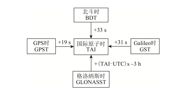
.1 시스템 시간 변환 관계
4 Comparative analysis of GNSS service performance
The service performance of satellite navigation systems includes accuracy, integrity, continuity and availability, of which users are most concerned about accuracy and availability.서비스 정확도는 위치 정확도, 속도 측정 정확도 및 시간 측정 정확도를 포함합니다. 위치 정확도는 사용자가 위성 신호를 이용하여 측정한 위치와 실제 위치 간의 차이에 대한 통계값으로, 수평 위치 정확도와 수직 위치 정확도를 포함합니다. 속도 측정 정확도는 사용자가 위성 신호를 이용하여 측정한 속도와 실제 속도 간의 차이에 대한 통계값으로, 일반적으로 3차원 공간 속도 오차를 나타냅니다. 시간 측정 정확도는 위성 신호를 이용하여 측정한 시간과 위성 항법 시스템의 시간 간의 차이에 대한 통계값입니다.Service availability is the ratio of system service time to expected service time. The serviceable time is the time when the position dilution of precision (PDOP) availability and positioning availability within the specified area meet the requirements. PDOP availability is the percentage of time that the PDOP value meets the threshold requirements within a specified geographical or spatial area and time period. Positioning availability is the percentage of time that the positioning accuracy meets the threshold requirements within the specified service area and time period.항법 시스템의 위치 정확도는 주로 두 가지 요소에 의해 결정됩니다. ① PDOP 값, ② 사용자 등가 거리 오차(UERE). UERE는 사용자 거리 오차(URE)와 사용자 장비 오차(UEE)로 구성됩니다. 그중 URE는 항법 위성의 궤도 오차와 위성 시계 오차로 인해 위성에서 사용자 단말기까지의 거리 관측 오차가 합산된 것으로, 주로 위성 항법 시스템에 의해 결정됩니다. UEE는 지상 다중경로 효과 및 사용자 수신기 루프 잡음 등으로 인해 발생하는 오차로, 주로 사용 환경과 수신기 설계에 의해 결정됩니다.BDS, GPS, Galileo 및 GLONASS의 서비스 성능 사양 및 최신 공식 회의 자료를 기반으로 함[3,14-17], the public service performance parameters of each global satellite navigation system were sorted out, and the results are shown in Table 5. In Table 5, RMS (root mean square) represents the root mean square.
시스템 이름 | URE/분 | URRE/(m·s-1) | 95% 신뢰도에서의 위치 정확도(미터당) | 속도 측정 정확도/ | 95 % 신뢰성 | |
수평 방향 | 고도 방향 | |||||
BDS | B1C/B2a:0.6(RMS) | 0.006(RMS) | 10 | 10 | 0.2(95%) | 20 |
B1I/B3I:1(RMS) | ||||||
GPS | 신뢰도 95%에서의 결과는 7.8입니다. | 신뢰도 95%에서의 결과는 0.006입니다. | 9 | 15 | 0.1 | 40 |
갈릴레오 | 신뢰도 95%에서의 결과는 7입니다. | - | 4 | 8 | - | 30 |
GLONASS | 신뢰도 95%에서의 결과는 18입니다. | 신뢰도 95%에서의 결과는 0.02입니다. | 5 | 9 | - | 700 |
表5 GMSS서비스 성능 매개변수 노출
실제로 각 위성항법 시스템의 측정된 성능은 약속된 공공 서비스 성능보다 우수합니다. 이는 2019년 제14차 국제 위성항법시스템위원회(ICG) 회의에서 중국 위성관리국이 발표한 보고서에 따른 것입니다.[18], the measured horizontal positioning accuracy of BDS B1I/B3I is 3.6 m (result under 95% reliability), the altitude positioning accuracy is 6.6 m (result under 95% reliability), the speed measurement accuracy is 0.05 m/s (result under 95% reliability), and the timing accuracy is 9.8 ns (result under 95% reliability). The measured horizontal positioning accuracy of B1C/B2a is 2.4 m (95 The result under 95% reliability), the altitude positioning accuracy is 4.3 m (the result under 95% reliability), the speed measurement accuracy is 0.06 m/s (the result under 95% reliability), and the timing accuracy is 19.1 ns (the result under 95% reliability).According to the National Coordination Office of the 14th ICG Conference in 2019室(국가조정실, NCO)의 报告[19], the statistical results from 2018-11-14 to 2019-11-13 show that the average URE of GPS is 0.514 m, the best day URE is 0.362 m, and the worst day URE is 0.666 m. According to the report of the European Space Agency at the 14th ICG Conference in 2019[20-21]2019년 9월에 계산된 갈릴레오 위성의 URE는 0.27m(95% 신뢰도 이하 결과)였으며, 적도 지역에서 관측된 최악의 위치 정확도는 2.79m(95% 신뢰도 이하 결과)였습니다.
5 결론
This article makes a detailed comparison of the four existing GNSS, analyzes the constellation characteristics of the system, and points out the advantages of the BOS MEO/IGSO/GEO combined constellation; summarizes the signal system of each navigation system, highlighting the advantages of multi-system compatibility and interoperability and BDS information encoding; conducts a comparative analysis of the coordinate system and time system of each system; analyzes the service performance of the satellite navigation system,각 탐색 시스템의 서비스 성능 매개변수가 요약되어 있습니다.비교 분석을 통해 BDS가 세계화되면서 첨단 기술, 완벽한 기능, 탁월한 성능, GPS 및 갈릴레오와의 우수한 호환성 및 상호 운용성, 그리고 완전한 독자적인 지적 재산권을 확보했음을 알 수 있습니다. BDS는 GPS와 함께 발전하는 단계에 있으며, 이는 BDS가 세계로 진출하여 국제적인 주류로 자리매김하는 데 중요한 기반이 됩니다. 국가가 자원과 인력에 대한 투자를 지속적으로 확대함에 따라, 가까운 미래에 BDS가 해외 GNSS를 선도할 것으로 기대됩니다.
본 기사는 지적재산권 보호를 위해 "측량 및 지도 제작 학술 정보"에서 재인쇄되었습니다. 재인쇄 시 원출처와 저자를 명시해 주시기 바랍니다. 저작권 침해 사항이 있을 경우 삭제를 위해 저희에게 연락해 주십시오.
관련 추천
Kinghelm 영업 부국장 펑후이성: 선전의 하카족 출신으로, 끊임없는 노력으로 초심을 잃지 않고 살아가고 있다
2026-08-03
2243
송스창의 전략론: 2026 상하이 일렉트로니카 다이얼로그 주요 내용
2026-07-21
2447