






















Service Hotline
News

News

A brief analysis of the world's four major satellite navigation systems
2021-12-28
1151
worldwide4A brief analysis of large satellite navigation systems
Abstract: In order to further study satellite navigation systems, a comparative analysis of the four existing global satellite navigation systems is conducted: Beidou Satellite Navigation System (BDS), Global Positioning System (GPS), Galileo Satellite Navigation System (Galileo) and GLONASS Satellite Navigation System (GLONASS) are compared from the aspects of constellation, signal system, coordinate and time system and service performance; the advantages of BDS are pointed out. The results show that BDS has great advantages in system constellation and information encoding, and the system service performance is equivalent to GPS and Galileo, and better than GLONASS; BDS is based on geostationary orbit (GEO), inclined geosynchronous orbit (IGSO) and mesospheric earth The constellation distribution of orbits (MEO) can improve positioning accuracy and availability in the Asia-Pacific region; the 64-base low-density parity check (LDPC) encoding used by BDS is better than the encoding methods of other systems. Compared with the binary LDPC encoding of GPS, it can bring 0.6~1.2 dB of additional gain.
Keywords: global satellite navigation system; system constellation; signal system; coordinate system; system time; service performance
0 引言
目前有4大全球卫星导航系统(global navigation satellite system, GNSS),包括中国的北斗卫星导航系统(BeiDou navigation satellite system, BDS)、美国的全球定位系统(global positioning system, GPS)、欧盟的伽利略卫星导航系统(Galileo navigation satellite system, Galileo)和俄罗斯的格洛纳斯卫星导航系统(global orbiting navigation satellite system, GLONASS)。其中,BDS和GPS已服务全球,性能相当;功能方面,BDS较GPS多了区域短报文和全球短报文功能. Although GLONASS has been in service around the world, its performance is slightly inferior to BDS and GPS, and the GLONASS orbit has a large inclination, resulting in poor performance in low latitudes. The quality of Galileo's observations is better, but the stability of the satellite clock is slightly poorer, resulting in poor system reliability.
GNSS is mainly composed of space segment, ground segment and user segment. Its working principleas follows:
1) The navigation satellites distributed according to the constellation in the space segment receive clock correction, ephemeris and other information injected uplink from the ground segment for signal modulation, and broadcast signals to the ground according to the prescribed signal system.
2) The ground segment tracks and maintains space satellites, monitors the health of the satellites, evaluates the integrity of the satellites and signals, determines the satellite's orbit, and injects the satellite's clock correction, ephemeris, almanac, ionospheric correction parameters and other information uplink into the satellite at specific frequencies.
3) The user segment receives signals from each visible satellite, and performs position, velocity, and time (PVT) calculations based on the observations obtained from the tracking signal and the ephemeris and time information obtained from the demodulated signal to determine the user's position, velocity, and time information.The navigation system space segment mainly includes two important characteristics:
① A space constellation that represents the spatial distribution of satellites;
②Characteristics of satellite broadcast signals. As far as the entire system is concerned, what users are most concerned about is its service performance. This article mainly compares the space constellation, signal system, coordinate and time system and service performance of GNSS, and analyzes the characteristics of BDS on this basis.
1 Comparative analysis of GNSS constellations
The elements of a satellite navigation system space constellation mainly include constellation type, satellite type, number of satellites, orbital altitude, orbital inclination, etc. The constellation distribution of GPS, Galileo and GLONASS is roughly the same, and the satellites are all medium Earth orbit (MEO) satellites. The BDS constellation includes MEO satellites, inclined geosynchronous orbit (IGSO) satellites and geostationary orbit (GEO) satellites. BDS's three GEO satellites are located above the equator, respectively distributed at 80°E, 110.5°E and 140°E. BDS’s three IGSO satellites are distributed in three orbital planes[3]. BDS's 24 MEO satellites are evenly distributed in three orbital planes, and their subsatellite point trajectories cover the world. Through the MEO/IGSO/GEO constellation layout, BDS can greatly improve the visibility of BDS satellites in the Asia-Pacific region, thereby improving the positioning accuracy and availability of BDS.
Satellite navigation system name | Navigation satellite parameters of different satellite navigation systems | |||||||
Constellation type | satellite | Number of different types of satellites | Different types of satellite orbit heights/km | different types of satellites | different types of satellites | track surface | Constellation distribution repetition period (times/day) | |
BDS | MEO's constellation is Walker type 24/3/1 | GEO IGSO MEO | 3 3 24 | 35 786 35 786 21 528 | — 55 55 | — 23 h 56 min 4 s 12 h 55 min | — — 3 | 13/7 (Repeat 13 times in 7 days) |
GPS | Non-Walker constellations | MEO | 24 | 20 200 | 55 | 11 h 58 min | 6 | 2/1 (Repeat 2 times a day) |
Galileo | Walker型星座24/3/1 | MEO | 24 | 23 222 | 56 | 14 h 4 min 45 s | 3 | 17/10 (Repeat 17 times in 10 days) |
GLONASS | Walker型星座 24/3/2 | MEO | 24 | 19 100 | 64.8 | 11 h 15 min 44 s | 3 | 17/8 (Repeat 17 times in 8 days) |
表1 Global satellite navigation system space constellation comparison
2 Comparative analysis of GNSS systems
Each of the four major satellite navigation systems has its own characteristics. As for the multi-access mechanism, the multi-access mechanism of BDS, GPS and Galileo is code division multiple access (CDMA). The multi-access mechanism of GLONASS is currently frequency division multiple access (FDMA). Its modernization plan is to develop towards CDMA. As far as signal components are concerned, in addition to some authorized or proprietary signal components for special purposes, BDS, GPS and Galileo haveAfter a period of research and coordination, a compatible and interoperable cooperation agreement was reached on civil public signals, realizing the interoperability between BDS B1C and B2a with GPS L1, L5 and Galileo E1 and E5a respectively, which can greatly improve the service performance of satellite navigation systems and reduce the development cost of multi-system user terminals.Table 2 mainly compares and analyzes the four major satellite navigation signal systems from the aspects of signal frequency, signal branch, modulation method, information encoding method, symbol rate and signal bandwidth, so that readers can have a comprehensive and systematic understanding of the signals of each system.
System name | Signal | Signal | Carrier frequency/MHz | Modulation method | Information encoding method | Symbol rate (in "per second "sampling times") | main lobe band | Broadcast satellite type |
BDS | B1I | I road | 1 561.098 | BPSK(2) | BCH(15,11,1)+interleaved | 50 | 2.046 0 | GEO/IGSO/MEO |
B1C | B1C_data | 1 575.420 | BOC(1,1) | BCH(21,6)+BCH(51,8)+64进制LDPC(200,100)+64进制LDPC(88,44)+交织 | 100 | 32.736 0 | IGSO/MEO | |
B1C_pilot | QMBOC(6,1,4/33) | — | 0 | |||||
B2a | B2a_data | 1 176.450 | QPSK(10) | 64进制LDPC(96,48) | 200 | 20.460 0 | IGSO/MEO | |
B2a_pilot | — | 0 | ||||||
B2b | I road | 1 207.140 | QPSK(10) | 64进制LDPC(162,81) | 1000 | 20.460 0 | IGSO/MEO | |
B3I | I road | 1 268.520 | QPSK(10) | BCH(15,11,1)+interleaved | 50 | 20.460 0 | GEO/IGSO/MEO | |
GPS | L1 | C/A | 1 575.420 | BPSK(1) | Hamming code (32,26) | 50 | 2.046 0 | MEO |
P(Y) | BPSK(10) | encryption | 50 | 20.460 0 | ||||
M | BOC(10,5) | encryption | — | 30.690 0 | ||||
L1C | L1C-D | 1 575.420 | BOC(1,1) | CRC-24Q+BCH(51,8)+binary LDPC(1200,600)+block interleaving | 100 | 4.092 0 | MEO | |
L1C-P | TMBOC(6,1,4/33) | — | — | 14.332 0 | ||||
L2 | P(Y) | 1 227.600 | BPSK(10) | encryption | 50 | 20.460 0 | MEO | |
C | BPSK(1) | CRC-24Q+ convolutional encoding (600,300) | 50 | 2.046 0 | ||||
M | BOC(10,5) | encryption | — | 30.690 0 | ||||
L5 | L5C | 1 176.450 | QPSK(10) | CRC-24Q+ convolutional encoding (600,300) | 100 | 20.460 0 | MEO | |
L5Q | encryption | — | ||||||
Galileo | E1 | E1-A | 1 575.420 | BOCCOS(15,2.5) | encryption | 100 | 35.805 0 | MEO |
E1-B | CBOC(6,1,1/11,’+’) | CRC-24Q + convolutional encoding (240,120) + interleaving | 4.092 0 | |||||
E1-C | CBOC(6,1,1/11,’+’) | — | 4.092 0 | |||||
E5a | E5a-I | 1 176.450 | AltBOC(15,10) | CRC-24Q + convolutional encoding (488,244) + interleaving | 50 | 51.150 0 | MEO | |
E5b | E5b-I | 1 207.140 | CRC-24Q + convolutional encoding (240,120) + interleaving | 250 | ||||
E6 | E6-A | 1 278.750 | BOCCOS(10,5) | encryption | 100 | 30.690 0 | MEO | |
E6-B | BPSK(5) | encryption | 1000 | 10.230 0 | ||||
E6-C | BPSK(5) | — | — | 10.230 0 | ||||
GLONASS | G1 | 1 598.0 625~1 605.375 | BPSK | Hamming code | 100 | 8.334 5 | MEO | |
G2 | 1 242.9 375~1 248.625 | BPSK | Hamming code | 100 | 6.709 5 | |||
表2 GNSSComparison of signaling systems[4-9]
表2中:BPSK(binary phase shift keying)表示二相移相键控;QMBOC(quadrature multiplexed binary offset carrier)表示正交复用二进制偏移载波调制;TMBOC(time multiplexed binary offset carrier)表示时分复用二进制偏移载波;CBOC(composite binary offset carrier)表示复合二进制偏移载波;BCH(Bose Chaudhuri Hocquenghem)表示Bose、Chaudhuri及Hocquendhem各自独立发现的二元线性循环码;CRC(cyclic redundancy check)表示循环冗余校验。As can be seen from Table 2, the B1C signal of BDS, the L1C signal of GPS and the E1 signal of Galileo work at 1 575.42 MHz, and the debugging method is binary offset carrier (BOC) type modulation; the B2a signal of BDS, the L5 signal of GPS and the E5a signal of Galileo work at 1 176.45 MHz, where B2a and L5 are quadrature phase shift keying (QPSK) modulation methods, and E5a is alternating binary offset carrier (AltBOC) modulation method. The consistency of frequencies and the similarity of modulation methods create prerequisites for GNSS compatibility and interoperability. Currently, compatibility and interoperability can be achieved very well at 1 575.42 MHz.In terms of navigation message design, BDS introduced 64-base low density parity check (LDPC) encoding as an important feature into navigation message encoding. Its encoding and decoding schemes were independently developed by China, and its performance is greatly improved compared to the binary LDPC encoding of GPS. The complexity of 64-base LDPC encoding and binary LDPC encoding are basically the same; in terms of decoding, the complexity of 64-base decoding is about 6 times that of binary decoding. Bit error rate is 1×10⁻⁵Under the conditions, the 64-ary LDPC coding gain is 0.6~1.2 dB higher than the binary LDPC coding gain, which brings considerable benefits to the improvement of cold start related indicators of the user terminal.。
3 Comparative analysis of GNSS coordinates and time systems
3.1 Comparative analysis of coordinate systems
The coordinate system of the satellite navigation system is particularly important. The satellite position and satellite speed calculated from the satellite ephemeris parameters and almanac parameters are directly represented in the system coordinate system. The system coordinate system defines the datum ellipsoid required to establish the corresponding geodetic coordinate system, describes the Earth's gravity field model corresponding to the geoid, and provides corrected basic geodetic parameters. The corrected basic geodetic parameters of each system are shown in Table 3.
System name | Coordinate system name | Coordinate system parameters | |||
Ellipsoid length/m | oblateness | gravitational constant/ | Earth's rotation angular velocity/ | ||
BDS | BDCS | 6 378 137.00 | 1/298.257 222 101 | 3.986 004 418 | 7.292 115 |
GPS | WGS84 | 6 378 137.00 | 1/298.257 223 563 | 3.986 004 418 | 7.292 115 |
Galileo | GTRF | 6 378 136.55 | 1/298.257 690 000 | 3.986 004 418 | 7.292 115 146 7 |
GLONASS | PZ90 | 6 378 136.00 | 1/298.257 839 303 | 3.986 004 418 | 7.292 115 |
表3 Basic geodetic parameters of each coordinate system[4-9]
The BeiDou coordinate system (BDCS) is a geocentric earth reference system. The definition of BDCS complies with the International Earth Rotation Service (IERS) specification and uses the reference ellipsoid parameters of China geodetic coordinate system 2000 (CGCS2000). The main difference from CGCS2000 is the update frequency. BDCS is a special coordinate system for BDS and can be updated once a year or half a year; CGCS2000 is a national coordinate system with a wide range of correlations and a long update interval. The implementation of BDCS will be aligned with the latest international terrestrial reference frame (ITRF). WGS84 (world geodetic system 84) is the geodetic coordinate system used by the US GPS; GTRF (Galileo terrestrial reference frame) is the geodetic coordinate system used by the EU Galileo; PZ-90 (PZ-90 geodetic system) is the geodetic coordinate system established by Russia.
3.2 Comparative analysis of time systems
The time system is the core of the satellite navigation system and the cornerstone of the normal operation of the satellite navigation system. BDS, GPS and Galileo have all established dedicated time systems based on atomic time (AT). Their second lengths are synthesized based on the observations of atomic clocks and satellite atomic clocks installed on their ground monitoring stations. They are still essentially atomic time and therefore continuous, without the need for leap seconds like coordinated universal time. GLONASS system time (GLONASST) is different from the other three system times. It is an atomic time system similar to coordinated universal time (UTC). It introduces leap seconds during operation, uses Moscow time as the benchmark, and traces its origin to the coordinated universal time UTC (SU) maintained by the Russian Institute of Time Metrology.BeiDou time (BDT) is generated and maintained by the BDS master control station, and is traceable to Coordinated Universal Time (NTSC) maintained by the National Time Service Center. GPS time (GPS time, GPST) is generated and maintained by the GPS master control station and is traceable to Coordinated Universal Time UTC (USNO) maintained by the U.S. Naval Observatory.[12]。Galileo时(Galileo time, GST)直接溯源到国际计量局(International Bureau of Weights and Measures, BIPM)保持的协调世界时UTC(BIPM)。International atomic time (TAI) is measured in atomic seconds and accumulates from universal time (UT) 0:00 on January 1, 1958. At this time, the difference between universal time and international atomic time is zero, and then increases year by year. In 1972, in order to harmonize the differences between International Atomic Time and Universal Time, a compromise plan was proposed, namely Coordinated Universal Time. Coordinated Universal Time is based on the precise TAI second length. When the difference between it and Universal Time exceeds 0.9 s, a leap second is added artificially by 1 s, so that the difference between Universal Time and Coordinated Universal Time is always within 0.9 s.[13]. The system time comparison of the four major satellite navigation systems is shown in Table 4.
satellite navigation | Time system parameters of different satellite navigation systems | |||
Time system name | Starting epoch | Is it continuous? | Lag TAI time/s | |
BDS | BDT | 2006-01-01 00:00:00(UTC) | yes | 33 |
GPS | GPST | 1980-01-06 00:00:00(UTC) | yes | 19 |
Galileo | GST | 1999-08-22 00:00:00(UTC)前13 s | yes | 19 |
GLONASS | GLONASST | 滞后UTC(SU) 3 h | no | Changes with leap seconds |
表4 GNSSTime system comparison
According to comparative analysis, the starting epoch of GST is set to 13 seconds before 1999-08-22T 00:00:00 (UTC) in order to be consistent with GPST. Both GST and GPST lag TAI by 19 seconds.
The conversion relationship between each system time is shown in Figure 1.
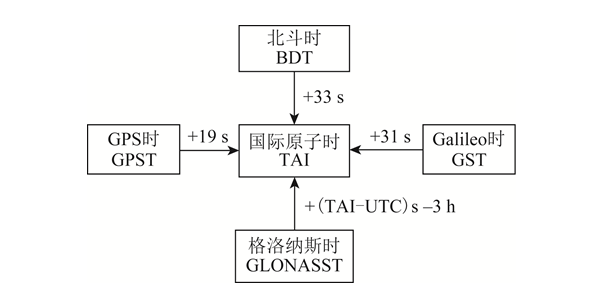
picture1 System time conversion relationship
4 Comparative analysis of GNSS service performance
The service performance of satellite navigation systems includes accuracy, integrity, continuity and availability, of which users are most concerned about accuracy and availability.Service accuracy includes positioning accuracy, speed measurement accuracy and time measurement accuracy. Positioning accuracy is the statistical value of the difference between the position determined by the user using satellite signals and its true position, including horizontal positioning accuracy and vertical positioning accuracy. Speed measurement accuracy is the statistical value of the difference between the speed determined by the user using satellite signals and its true speed, which is generally the three-dimensional space speed error. Time measurement accuracy is the statistical value of the difference between the time determined using satellite signals and the time of the satellite navigation system.Service availability is the ratio of system service time to expected service time. The serviceable time is the time when the position dilution of precision (PDOP) availability and positioning availability within the specified area meet the requirements. PDOP availability is the percentage of time that the PDOP value meets the threshold requirements within a specified geographical or spatial area and time period. Positioning availability is the percentage of time that the positioning accuracy meets the threshold requirements within the specified service area and time period.The positioning accuracy of the navigation system is mainly determined by two factors: ① PDOP value; ② user equivalent range error (UERE). UERE consists of user range error (URE) and user equipment error (UEE). Among them: URE is the sum of errors in the distance observation from the satellite to the user terminal caused by errors in the navigation satellite orbit and satellite clock error, which is mainly determined by the satellite navigation system; UEE is the error caused by ground multipath effects and user receiver loop noise, etc., which is mainly determined by the use environment and the design of the local receiver.Based on service performance specifications and latest official conference materials from BDS, GPS, Galileo and GLONASS[3,14-17], the public service performance parameters of each global satellite navigation system were sorted out, and the results are shown in Table 5. In Table 5, RMS (root mean square) represents the root mean square.
System name | URE/m | URRE/(m·s-1) | Positioning accuracy/m at 95% reliability | Speed measurement accuracy/ | 95% reliability | |
horizontal direction | elevation direction | |||||
BDS | B1C/B2a:0.6(RMS) | 0.006(RMS) | 10 | 10 | 0.2(95 %) | 20 |
B1I/B3I:1(RMS) | ||||||
GPS | The result at 95% reliability is 7.8 | The result at 95% reliability is 0.006 | 9 | 15 | 0.1 | 40 |
Galileo | The result at 95% reliability is 7 | — | 4 | 8 | — | 30 |
GLONASS | The result at 95% reliability is 18 | The result at 95% reliability is 0.02 | 5 | 9 | — | 700 |
表5 GMSSExpose service performance parameters
In fact, the measured performance of each satellite navigation system is better than the promised public service performance. According to the report of the China Satellite Management Office at the 14th International Committee on Global Navigation Satellite System (ICG) meeting in 2019[18], the measured horizontal positioning accuracy of BDS B1I/B3I is 3.6 m (result under 95% reliability), the altitude positioning accuracy is 6.6 m (result under 95% reliability), the speed measurement accuracy is 0.05 m/s (result under 95% reliability), and the timing accuracy is 9.8 ns (result under 95% reliability). The measured horizontal positioning accuracy of B1C/B2a is 2.4 m (95 The result under 95% reliability), the altitude positioning accuracy is 4.3 m (the result under 95% reliability), the speed measurement accuracy is 0.06 m/s (the result under 95% reliability), and the timing accuracy is 19.1 ns (the result under 95% reliability).According to the National Coordination Office of the 14th ICG Conference in 2019室(National Coordination Office, NCO)的报告[19], the statistical results from 2018-11-14 to 2019-11-13 show that the average URE of GPS is 0.514 m, the best day URE is 0.362 m, and the worst day URE is 0.666 m. According to the report of the European Space Agency at the 14th ICG Conference in 2019[20-21], the Galileo satellite URE calculated in September 2019 was 0.27 m (result under 95% reliability), and the worst positioning accuracy monitored in the equatorial region was 2.79 m (result under 95% reliability).
5 Conclusion
This article makes a detailed comparison of the four existing GNSS, analyzes the constellation characteristics of the system, and points out the advantages of the BOS MEO/IGSO/GEO combined constellation; summarizes the signal system of each navigation system, highlighting the advantages of multi-system compatibility and interoperability and BDS information encoding; conducts a comparative analysis of the coordinate system and time system of each system; analyzes the service performance of the satellite navigation system,The service performance parameters of each navigation system are summarized.Through comparative analysis, it can be seen that after the globalization of BDS, it has advanced technology, complete functions, excellent performance, excellent compatibility and interoperability with GPS and Galileo, and has completely independent intellectual property rights. It is in the stage of running alongside GPS, which provides an important guarantee for BDS to go global and become the international mainstream. As the country continues to invest heavily in resources and manpower, it is expected that BDS will lead foreign GNSS in the near future.
This article is reprinted from "Surveying and Mapping Academic Information" to support the protection of intellectual property rights. Please indicate the original source and author when reprinting. If there is any infringement, please contact us to delete it.
Related Recommendations