






















Service Hotline
News

News

Autonomous driving positioning technology GNSS positioning
2021-12-28
935
Autonomous driving positioning technology is one of the key technologies for realizing autonomous driving.
In layman's terms, the fundamental problem that driverless driving needs to solve is: Where are you now? Where are you going? Which way to go?
The question "where are you now" is the positioning technology we are going to discuss today. A self-driving car can only decide where to go next if it knows its location and then combines the surrounding environment information and destination information.
There are currently three types of high-precision positioning technologies used for autonomous driving:
1.Positioning based on electronic signals, such as Global Satellite Navigation System GNSS;
2.Track reckoning, a technology based on the IMU inertial measurement unit, estimates the current position and direction based on the position and direction at the previous moment;
3.Environmental feature matching, that is, positioning based on lidar and visual sensors, such as lidar matching, requires first establishing a point cloud map, and then matching the data collected by the lidar in real time with the point cloud to determine the current location information of the vehicle.
Each of these three methods has its own advantages. Today we will take a look at GNSS positioning technology first.
You may be unfamiliar with GNSS, but if you talk about GPS or Beidou (BDS), you are familiar with it.
GNSS(Global navigation satellite system)就是global navigation satellite system, is a general term that includes GPS in the United States, BDS in China, GLONASS in Russia, GALILEO in Europe, etc.
The principle is easy to understand, that isDetermine the position of a ground receiver using four satellites with known positions. We take GPS as an example to explain the principle of satellite positioning.
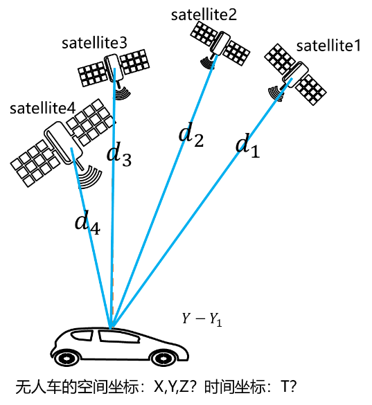
Every GPS satellite operating in the universe is constantly broadcasting its current position coordinate information to the world through satellite signals. Any GPS receiver can easily receive this information through its antenna and be able to read it, i.e.The spatial coordinates of the four satellites are known。
When the satellite sends the location information, it will also attach the timestamp when the data packet is sent. After the GPS receiver receives the data packet, it subtracts the time on the timestamp from the current time (of course the current time can only be determined by the GPS receiver itself), which is the time it takes for the data packet to be transmitted in the air. By multiplying the transmission time of the data packet in the air by the transmission speed, you can get the distance the data packet is transmitted in the air, which is the distance from the satellite to the GPS receiver. Right now,The distances of the four satellites to the GPS receiver are known。
Based on the knowledge of solid geometry, the current position information of the GPS receiver can be obtained.
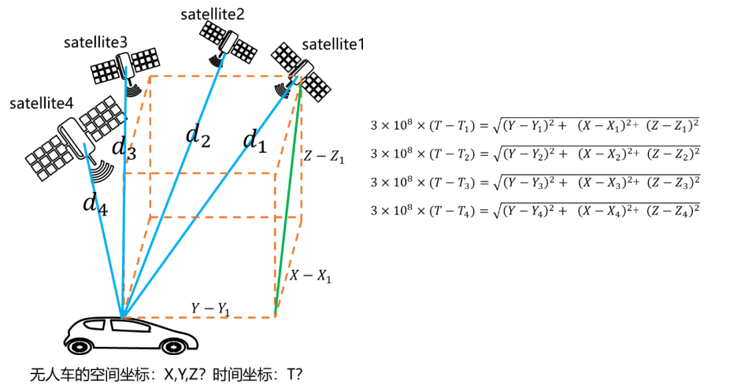
This positioning method is also calledSingle point positioningorabsolute positioning。
The most difficult problem to solve in GPS positioning is error. There are many reasons for positioning errors, such as caused by the ionosphere, caused by receiving equipment, obstruction, and multipath effects. Occlusion means that satellite signals cannot be received. The multipath effect means that not only the signals sent directly by the satellite are not received, but also the signals reflected by tall buildings are received. In this way, the propagation time will be wrong, and the calculated position will also be wrong.
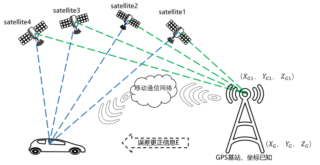
In order to improve the accuracy of GPS positioning and reduce errors, people add a parameter with known coordinatesTest the GPS receiver to improve positioning accuracy, this isDifferential positioning, also calledrelative positioning。
A ground-based augmentation system, commonly known as a base station, is deployed at a known coordinate point. The base station can also receive satellite signals, calculate the coordinate values based on these signals, and then compare them with the known coordinates to obtain the deviation. The deviation is then sent to the GPS receiver to be positioned in real time through a data transmission link (a data transmission link is equivalent to a data line, but this data line is wireless) or a mobile communication network. The GPS receiver to be positioned will make corrections based on the received information, thereby improving positioning accuracy.
Carrier phase difference technology (Real Time Kinematic, RTK) is a differential method that processes carrier phase measurements of two measuring stations in real time. Simply put, it sends the carrier phase collected by the base station to the receiver of the unmanned vehicle, and the receiver calculates the difference between the carrier phase observations of the machine and the base station to calculate the coordinates. Generally speaking, most errors between the receiver and the base station have time and space correlation, so most of the errors can be offset or reduced. When the distance between the two is not far, the carrier phase difference can make the positioning accuracy reach centimeter level.
This article is reprinted from "Automotive Technology Fresh Chat", which supports the protection of intellectual property rights. Please indicate the original source and author when reprinting. If there is any infringement, please contact us to delete it.
Related Recommendations