























サービスホットライン
ニュース

ニュース
特集|スマート都市鉄道における北斗システムの応用と展望
2021-12-28
523
統計によると、80%以上の人々が建物内、移動車両内、地下など、人目につかない空間で時間を過ごす。都市鉄道交通(以下「都市鉄道」という)は、非露出空間の典型的なシナリオとして、都市の大動脈であり、中心的な公共エリアであり、「新インフラ」の重要な建設エリアでもある。長年にわたり、非露出空間における測位、航法、タイミング、通信は、スマート都市鉄道の開発を阻害する世界的な技術的問題およびボトルネックとなってきた。
The Beidou Satellite Navigation System (hereinafter referred to as the "Beidou System"), as a global system that provides time and space information, is an important space infrastructure independently constructed and operated by my country. The system construction has been completed and is being applied and promoted in various industries. By applying the Beidou system and building a high-precision positioning network, a high-precision time synchronization network, a high-throughput communication network and a space digital platform based on it, it can play a fundamental supporting role in the construction of smart urban rail.
北斗システムの応用は、基本的、革新的、浸透的、推進力となるため、都市鉄道の発展形態、発展概念、発展モデル、運営モデルに大きな影響を与え、「北斗+都市鉄道」の新たな運営・管理モデルこの都市の形成は、乗客、企業、政府など多様な主体の様々なニーズを満たし、より安全で信頼性が高く、便利で快適、費用対効果が高く、環境に優しく省エネルギーなスマート都市鉄道システムを構築する。
#01
北斗システムとスマート都市鉄道
①北斗システムの応用と開発
現在、北斗システムは、運輸、海洋漁業、気象水文学、電力供給、災害救援・軽減などの分野で広く利用されており、大きな社会的・経済的利益を生み出しています。特に運輸分野では、車両の位置特定、輸送プロセスの監視・管理、インフラの安全監視などに広く活用されています。
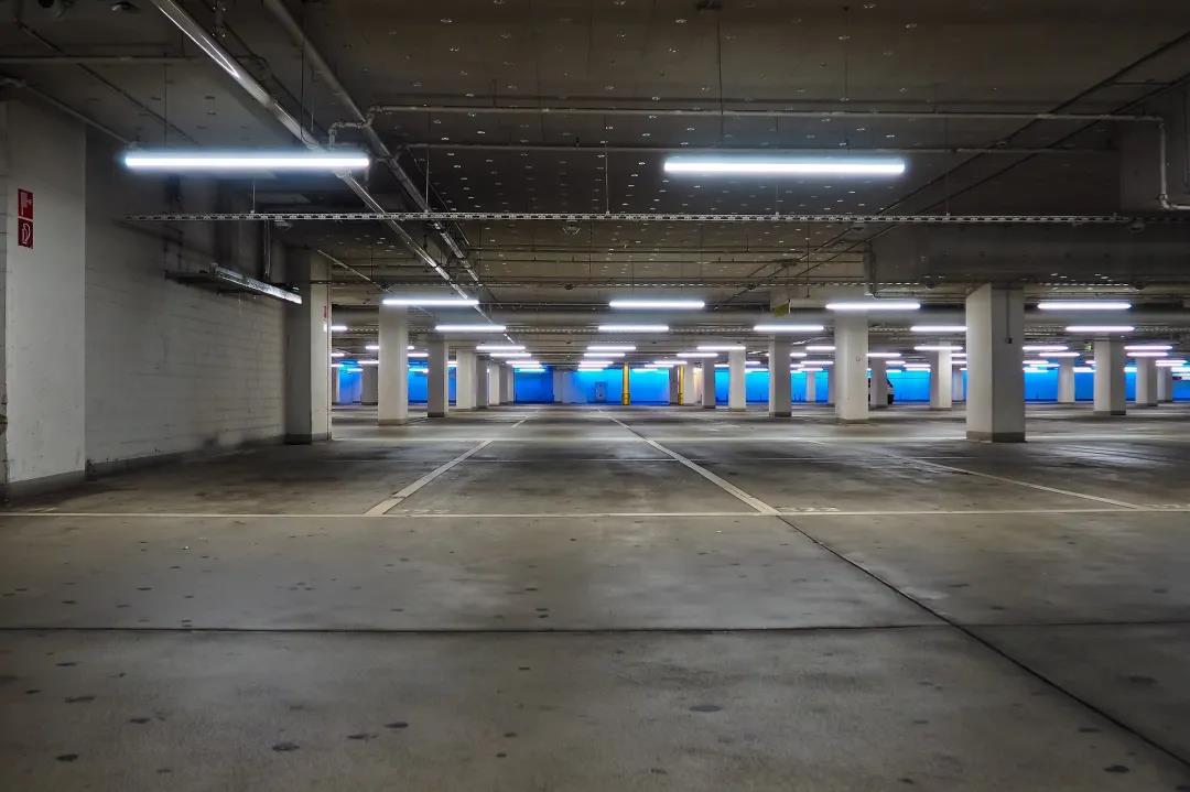
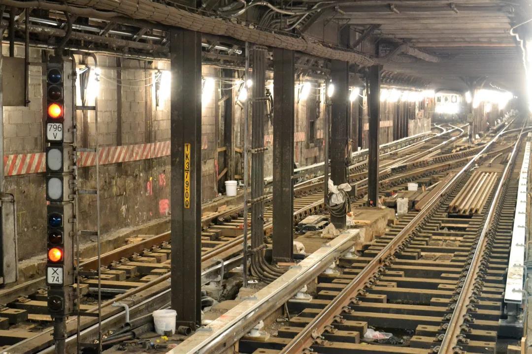
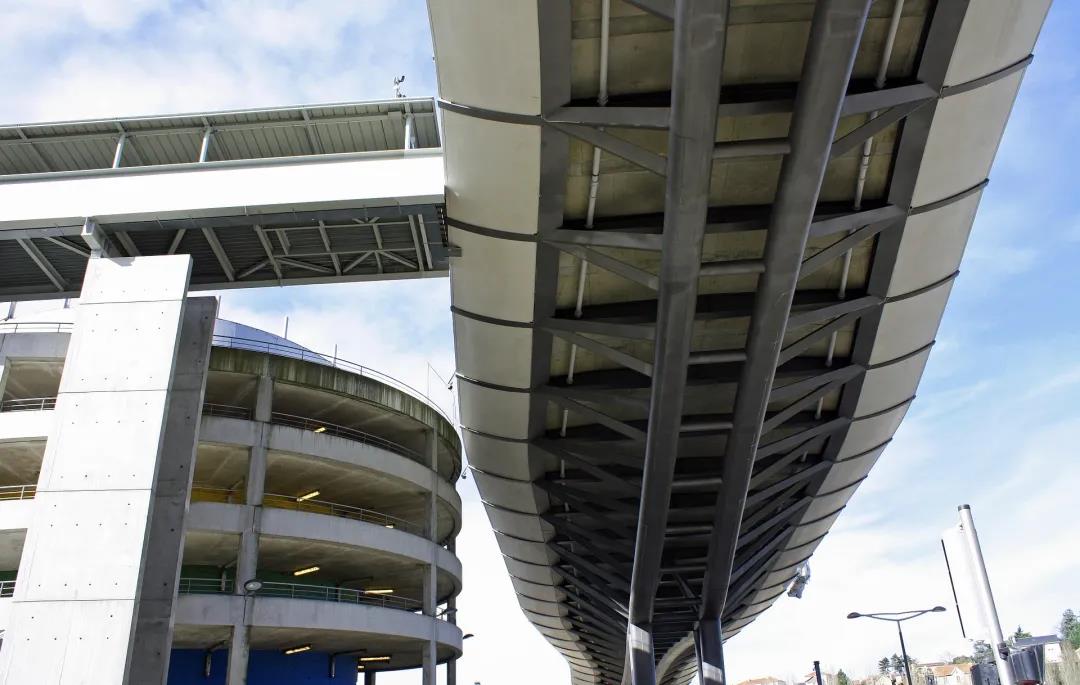
このことから、北斗システムの応用範囲をさらに拡大する余地がある。例えば、応用空間環境の観点から見ると、衛星航法システム信号を直接受信できる屋外露出空間環境(以下「露出空間」という)では、ユーザーは北斗システムが提供する時空間情報を直接利用できる。しかし、In non-exposed space environments where satellite navigation system signals cannot be received地下鉄、地下駐車場、商業施設、高架下など(以下「非露出空間」という)は、建物の障害物やマルチパス効果の影響を受けやすく、衛星測位の精度が著しく低下するため、非露出空間における位置情報サービスのニーズを満たすことができません。
なぜならPeople spend 80% of their time in non-exposed spaces such as buildings and mobile vehicles,therefore,非露出空間における航法および測位問題の解決は、北斗システムの応用開発における重要な方向性である。。

現在、中国は北斗システムをベースにした総合的な測位・航法・時刻同期(PNT)システムを構築している。このシステムは、異なる原理に基づく多様なPNT情報源を利用でき、クラウドプラットフォーム制御、マルチセンサーの高度統合、マルチソースデータ融合を通じて、統一された時空間ベンチマークを持つPNTサービス情報を生成する。これにより、耐干渉性、耐なりすまし性、堅牢性、使いやすさ、継続性、信頼性といった利点を持ち、屋内、水中、深宇宙などの分野をカバーすることが可能となる。
②北斗システムとスマート都市鉄道の統合開発
近年、建設の加速と運行距離の継続的な増加に伴い、都市鉄道はネットワーク化された運行、コスト削減と効率改善、高速サービス、低炭素環境保護、持続可能な開発といった一連の課題に直面している。こうした状況から、スマート都市鉄道という概念が生まれた。
輸送の本質は移動手段を提供すること、すなわち、必要に応じて輸送車両を用いて人や物の位置移動を実現することです。公共交通システムとして、スマート都市鉄道開発の中核目標は、安全性を確保しつつ、最小限のコストで最大限のカバー範囲で位置移動を実現することです。その方法は、情報技術のサポートを受けて都市鉄道サービスプロセスのすべてのリンクのインテリジェンスを実現すること、つまり「移動+」を実現することです。したがって、高度な情報通信、人工知能、IoT、ビッグデータ、ロボット工学などの技術を最大限に活用し、自律的な知覚、自律的な学習、自律的な意思決定、自律的な制御をコア処理プロセスとして、設備や施設の最適化された管理と制御に基づいて、乗客に効率的で正確かつパーソナライズされた移動サービスを提供し、より安全で、より効率的で、より快適で、より環境に優しい新世代の都市鉄道システムを構築する必要があります。
時間と空間の位置情報こそが、スマート都市鉄道システムの自律運行、精密な管理、そして常時パーソナライズされたサービスを実現するための基盤となる。, Therefore, the construction of smart urban rail needs to achieve integrated development with the Beidou system that provides spatio-temporal information.
都市鉄道の今後の発展傾向は、「移動+」の形で安全で便利、経済的、効率的で環境に優しいインテリジェント交通を推進することであり、一方、北斗システムの発展傾向は、「+北斗」の形で鉄道輸送産業を強化し(すなわち、北斗技術を基盤として、時空間情報を応用方法として、他産業の既存技術や既存事業と組み合わせたり、従来の応用ソリューションを置き換えたりして)、その変革と高度化を促進することです。「移動+北斗」は、北斗システムとスマート都市鉄道の統合的発展の中核概念として、都市鉄道と北斗システムの技術応用と産業エコシステムをさらに豊かにし、両者の総合的な発展を促進し、ひいては国家戦略の実現を促進します。
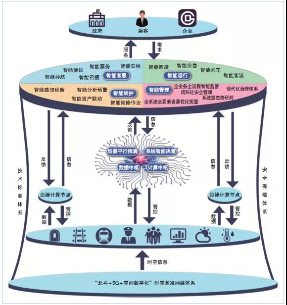
北斗システムとスマート地下鉄の統合開発
#02
スマート都市鉄道における北斗システムの需要
①Space-time benchmark
As a typical complex cyber-physical system, smart urban rail involves a wide variety of information systems such as automatic train control (ATC), automatic fare collection (AFC), power supply system management automation (SCADA), environmental monitoring (BAS), and fire alarm (FAS). In order to realize its autonomous operation, these complex information systems must be integrated to perceive, process, make decisions and control massive amounts of time and space information. Therefore, it is even more necessary to establish a unified spatio-temporal benchmark to avoid the risk of spatio-temporal information conflicts and endanger the safe operation of urban rail.測位および航行サービスを提供する北斗システムとそのCGCS2000座標系(我が国の最新の国家測地座標系)を適用することにより、都市鉄道システムは統一された、自律的で制御可能な時空間基準を得ることができる。
さらに、都市鉄道が位置する空間環境は非常に複雑で、露出空間と非露出空間が共存しています。衛星測位システムに頼るだけでは、現在のアプリケーションニーズを満たすことはできません。北斗システムの絶対時空間基準を都市鉄道の非露出空間に導入し、それを動的に維持することで、一方では非露出空間の相対位置と露出空間の絶対位置を統一し、都市鉄道における非露出空間の位置を絶対座標系の形で表示・適用することが可能になり、他方では非露出空間における時間を統一し、時間同期を実現することが可能になります。
②空間のデジタル化
Due to the complex spatial environment of urban rail, mastering rich and accurate geographical information is the basis for the construction and operation of smart urban rail. Spatial digitization, i.e.デジタル化された地理情報空間データフレームワーク(Digital Geospatial Data Framework,DSDF)の構築, is the product of the development and integration of surveying and mapping technology, geographic information technology and other modern information technologies.
With the advancement of technical means, surveying and mapping technology is developing in the direction of three-dimensional digitization, networking, real-time, and visualization of information collection, data processing, and application of results. There is a need for spatial digital application with three-dimensional real-life modeling as the core. In the construction of smart urban rail, it is necessary to use the spatio-temporal benchmark of the Beidou system to use station-mounted, push-broom, backpack, handheld and other surveying and mapping tools and geographical information data collection equipment to conduct computer rooms, station halls, sections, depots, and warehouses in the underground and above-ground spaces of the urban rail. In other places, we collect 3D laser point cloud data around spatial structures, equipment and facilities, consumables and other elements, and supplement it with data information such as on-site photography and textures to create a set of fine real-life 3D models with all elements to realize the spatial digitization of urban rail.
Using the above data, relevant staff can generate high-precision maps, sort out spatial resources, grasp the spatial structure and facilities and equipment of urban rail, provide accurate and comprehensive geographical information for the planning, construction, renovation and maintenance of smart urban rail, and provide important basic information and technical support for space utilization and refined management. As a new scenario application of Beidou technology in the space-time system, spatial digitization has injected new vitality into the development of smart urban rail.
③高精度な位置決めとタイミング
高精度な空間情報と時間情報は、スマート都市鉄道の構築の基盤となる。交通データは典型的な時空間データであり、時間次元の属性を持つだけでなく、空間構造にも強く依存している。
様々な鉄道交通情報システムの統合と発展に伴い、測位精度と時刻同期精度に対する要求はますます高まっています。現状では、北斗システムはスマート都市鉄道の高精度測位・時刻同期の要求を直接満たすことはできません。その理由は以下のとおりです。
衛星信号の受信が困難です。In the non-exposed space of urban rail, due to the shielding of walls (especially reinforced concrete), satellite positioning signals will be significantly weakened after passing through buildings, and the positioning accuracy will be greatly reduced, and the signal may even be unable to be received.
複数の障害物と干渉源。There are various types of obstacles in the urban rail, such as columns, elevators, escalators, equipment, screen doors, and pedestrians. The layouts are different. In addition, pedestrians and vehicles are moving all the time, and the signal will be reflected multiple times. These numerous uncertainties make the urban rail environment extremely complex. This situation is particularly prominent in the subway, because the subway environment is relatively closed, and complex environmental interference such as radio signals, sound, light, and temperature will have a negative impact on the accuracy of positioning equipment sensors.
標高の位置決めが難しい。地下鉄環境においては、二次元平面の位置だけでなく、多層建築物における地上階と地下階の位置と高さも考慮する必要がある。
アプリケーション端末の開発が難しい。Urban rail requires miniaturization, personalization, and combined application terminals, and solves problems such as component optimization design, material selection, precision manufacturing, deep component integration, real-time sensor calibration, and adaptive fusion of sensor output information. Researchers should start from the above four aspects and conduct targeted research to solve the above problems, so as to provide high-precision space and time information for the construction and operation of smart urban rail and ensure its smooth progress.
#03
Prospects for the application of Beidou system in smart urban rail
①時空間システムネットワークの構築
スマート都市鉄道は、自律的かつ制御可能な時空間システムネットワークを構築する必要がある。
北斗システムの非露出空間におけるナビゲーションおよび測位能力の欠如、高スループット通信手段の不足、および全要素地理情報の不足といった問題を踏まえ、「北斗+5G+空間デジタル化」技術を総合的に適用し、高精度測位ネットワーク、高精度時刻同期ネットワーク、高スループット通信ネットワーク、および空間デジタルプラットフォームから構成される「3つのネットワークと1つのプラットフォーム」時空間システムネットワークを構築すべきである。都市鉄道の時空間参照情報ネットワークを形成し、これをスマート都市鉄道の建設および運用のインフラとして使用し、統一的かつ連続的な空間および時間情報、ならびに都市鉄道の測位、時刻同期、および通信サービスを提供することにより、非露出空間における北斗システムのアプリケーションを補完、強化、およびバックアップし、都市鉄道の露出空間と非露出空間の間の障壁を打破する。
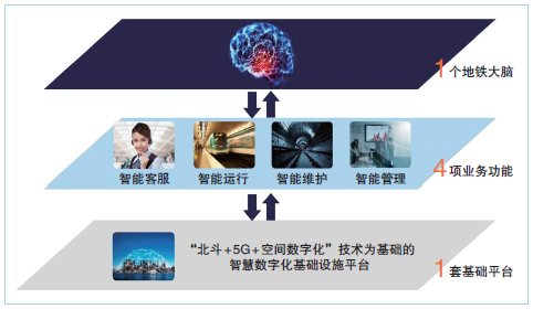
スマート都市鉄道時空間システムネットワークの構築
②突破すべき主要な技術的時空間ベンチマーク
スマートな都市鉄道時空間システムネットワークを構築するためには、屋内・屋外統合型高精度連続測位、汎用ネットワークプロトコルに基づく大規模高精度時間周波数伝送、5Gに基づく高スループット無線通信アプリケーションといった基幹技術のブレークスルーに注力する必要がある。

測位に関しては、統一された空間基準上で超広帯域(UWB)測位技術を主要な測位技術として使用し、複数の測位技術で補完・強化し、航法・測位ソフトウェアおよびアルゴリズムを統合することで、露出空間および非露出空間における連続測位を実現することが必要です。国が投資・構築した包括的なPNTシステムと、小型化・個別化・複合化されたサービス端末によって開発されたマイクロPNTシステムを通じて、高精度な位置情報サービスを提供できます。
In terms of time, it is necessary to achieve dynamic time synchronization of the entire network nodes in the intercity range based on the precision clock synchronization protocol of the IEEE 1588V2 network measurement and control system (also known as the Precision Time Synchronization Protocol (PTP)), combined with Synchronous Ethernet (SyncE) technology and the White Rabbit (WR) time synchronization method, on a unified time basis to provide high-precision timing services.
In terms of communications, it is necessary to develop urban rail indoor distribution systems and time slicing algorithms for subway services to realize the application of high-throughput communications. In addition, as the system construction progresses, it is also necessary to break through a series of key technologies used by the Beidou system in smart urban rail.
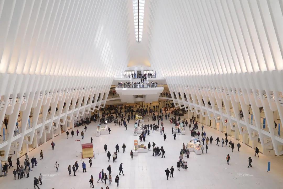
③Application servicesApplication is the starting point and goal of the integrated development of Beidou system and smart urban rail. The Beidou system will give urban rail new capabilities and means in terms of intelligent operation, intelligent maintenance, and intelligent customer service, provide effective support for urban rail business, and help build a smart urban rail system with sophisticated management, efficient operation, and maximum benefits.
In terms of intelligent operation, through the Beidou system, real-time high-precision location information of station, management and construction personnel can be obtained. On this basis, urban rail workers can be accurately managed through the construction of electronic fences, electronic roll-call and sign-in, performance appraisal analysis, etc. Train positioning is the guarantee for the safe and efficient operation of urban rail trains. The use of the Beidou system can make train positioning more accurate, more redundant, more autonomous, deeper integrated, and more efficient in linkage.
インテリジェントな保守管理の観点から見ると、都市鉄道の設備や機器は複雑で高度に自動化されており、資産規模も大きい。これらの保守管理は、都市鉄道運行の安全性と信頼性に直接的に影響する。北斗システムを用いて設備や機器の正確な位置情報を取得することで、資産管理システムにおいて正確な位置情報に基づいた資産・機器の自動在庫管理を実現し、状態監視、故障診断、リスク警告、保守評価、資産管理といった一連のプロセスが一元的に行われるようになる。
インテリジェントな顧客サービスという点では、北斗システムを利用することで、乗客は都市鉄道駅内外の自動券売機、自動販売機、トイレなどのサービス施設を素早く検索し、ルートを計画することができます。また、多次元・多層のデジタルマップに基づいたセルフサービスナビゲーション、スマートモバイル端末、ロボット誘導サービスなどの機能も実現でき、乗客の旅行ニーズに基づいた、常時パーソナライズされた旅行サービスを提供することが可能になります。
#04
結論
Time and space information have become basic information in modern production and life. The development of satellite navigation and positioning systems has completely changed people's lifestyles and also changed the management models of society and enterprises. With the completion and application promotion of the Beidou system, the construction and development of my country's smart urban rail have put forward higher requirements for spatiotemporal benchmarks, spatial digitization, high-precision positioning and timing.
将来、北斗システムとスマート都市鉄道は、統合に向けて大きな可能性と余地を秘めている。その核心は、都市鉄道の応用シナリオに基づいてPNTシステムを定義し、基幹技術を突破し、「3つのネットワークと1つのプラットフォーム」からなる時空間システムネットワークを構築することである。北斗システムの応用と普及は、都市鉄道のインテリジェント化に向けた最適な基礎条件を創出するだろう。
参照:
Lin Luzhou, Li Yujie, Deng Pingke, et al. Application and prospects of Beidou system in smart urban rail [J]. Modern Urban Rail Transit, 2021 (4):6-10。
This content comes from the Internet/Beidou Today. This website only provides reprinting. The views, stance, technology, etc. of this article have nothing to do with this website. If there is any infringement, please contact us to delete it!
関連おすすめ
Kinghelm 営業副部長の彭慧生:深圳に住む客家出身者、努力を通じて当初の志を貫く
2026-08-03
1308
ソン・シチャンが語る戦略:2026年エレクトロニカ上海対話のハイライト
2026-07-21
1370
清華大学の情熱: 材料科学における課題の克服 – CEN寧波金山新材料会社のCen Jianjun氏へのインタビュー
2026-07-14
1344
大胆なビジョン、勇敢な行動、次の波に乗るのはあなたかもしれない!―嘉正新城創業者、謝維新氏へのインタビュー
2026-06-30
1571